
Morning Update: Storm Sun into Mon SNOW & ICE ………..Brutal COLD late week and next weekend
Related Articles
2-8
10:45AM Update
This is a night mare forecast with the snow and ice line basically sitting over NNJ. Area just North of this line will see 6″ + if the line stays where it is at presently modeled – it is like telling a 4 year old to sit still while watching his/her favorite TV show! RGEM just came in which is the short range model of choice inside 24 hours of a rain or snow storm.
Here it is 10-15 mm equates to 4-6″


ICE ACCRETION – YIKES!!!!!

SO what are we looking at – a significant winter storm to impact the area tonight through Mon. Night possibly into early Tuesday morning – early AM 2AM ish.
A 15 mile jog South and the snow totals move south – a 15 mile jog North and NNJ sees less snow and more of a mix/ice. I am thinking a 4-6″ range for snow is going to be the norm with some isolated 6″+ spots like West Milford, Ringwood areas. NWS service is playing it safe right now saying 1-3″ with .25″ of ice but it lumps all of NNJ into the NYC Metro area which for weather purposes doesn’t hold at all – we are 5 degrees colder and always see more snow and ice in these set ups than NYC.
Unless things change this is the last update for this storm.
Be very careful tomorrow commuting.
Looking ahead:
Possible Miller B storm Thursday into Friday – for us in NNJ light to maybe moderate accumulation – this is a BASTAN crusher again!!
Then the cold comes in and WOW! Models showing the Polar Vortex as the media has hyped this to be sliding down to Philadelphia/Trenton Area – OH BOY – people will panic in that area thinking some thing bad is going to happen. No it just means it is going to be friggin brutally cold! Not saying these temps are etched in stone for lows next weekend but could very well verify

We shall see but it is a tough forecast none the less even for the pro mets!
Have a great day.
AL Q
Well peeps – got a 1/2″ of white gold this morning here in Hillsdale – yes sir good sign of things to come!! After digesting this mornings and last night data from the models it has come to my attention that we are trending colder and a tad wetter as depicted by the models below. As southern trend is occurring and the operational as well as ensemble members agree to this which is important!
There is an old saying Money makes money (just ask the millionaires and billionaires) and in the weather world (my world) SNOW breeds SNOW!!!! Look at this map of the snow cover and you’ll see what I mean. Look at the brown over SNJ, Balt and DC- good that is they way it is and should be – phenomenal song by Bruce Hornsby and the Range – come on you know it and listened to it – heck I still have the CD!!!

Now for the storm the GEFS are happy for our storm as I am now too – the trends continues!!!!

Dark shade of green says moderate snow 32 degree rain snow well actually sleet freezing rain like is into central jersey here.
I have the first snow map issued here and I give kudos to SNOWLover from my weather board for making this and allowing me to share this first call snow map, I agree with his call here. May not be 12″ but I think 6″+ is in general order for NNJ North!
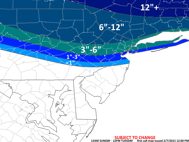
First Call Snow Map 2-7
Also we have to watch the coastal low – it looks to be further south and ride the coast in a NNE direction which if this were to come to fruition would enhance these snowfall amounts.
Much can still change either way here folks but i think we get a good snowstorm in the NNJ, NWNJ and LHV areas. I think NYC sees 3″+ and again more as you go North.
Late next week into the weekend – BITTER to BRUTAL COLD – a massive ridge in the west and a system over the Gulf of Alaska will drive the polar air into the east coast – our back yards – next storm chances are presidents holiday week cold to snow next weekend peeps. THERMALS X2 ALERT!!
REST OF FEBRUARY – MID MARCH
Looks to be cold and stormy into early-mid March – with the possibility of a long duration snowstorm and a blockbuster Nor’easter – I do not know when but the pattern is showing this going forward. hey last year we had a 6 week stretch from Jan 3 to Feb 13 of over 42″ of snow in NNJ – the=is year it is delayed for the back-end of winter and weak El Nino winters this is what happens – just like 1977-78.
Look at my winter outlook that I posted the other day in Seasonal Outlooks to see how I am doing so far this winter
Updates to come.
AL Q

Let me tell You a sad story ! There are no comments yet, but You can be first one to comment this article.
Write a comment