
EQ’s, Extreme Wx, Fall like pattern, Erin
Related Articles
Peeps,
Well, it’s been one extremely uncomfortable summer with raging dew points and humidity and high temperatures. Also, we had two earthquakes 3 miles apart and one was in my town about 1 mile from where I lived over 4 days this summer. We had extreme flooding in many parts of our area from torrential thunderstorms. We are a microcosm to the world’s macrocosm of wx extreme events from Dust Devils to Gorilla Sized (Softball) Hail, the Debris Flows, Earth Cracks, Earthquakes, Tsunamis. Volcanoes, Extreme Flash Flooding, Extreme Heat and Cold and insect invasions. One cannot keep up with all of this, it is a complete overload of information.
NJ, NY has had their fair share of extreme events so far – sinkholes, flooding, heat, earthquakes, and yes cold this summer.
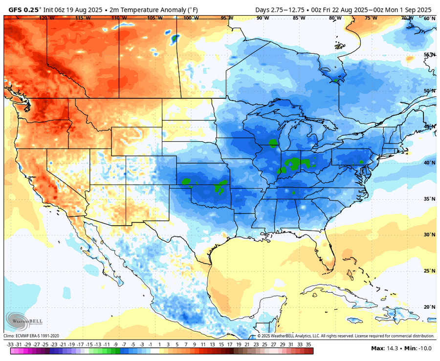
Fall Like Pattern
Peeps, isn’t this wx special we have right now through the end of the month? My goodness is remarkable. Cool nights in the upper 50’s to low 60’s to daytime highs in the 70 -75 range with low humidity. To dry but we need to be careful about what we wish for.
Next 12 days are below normal temperatures by a good 3-4* plus.
Erin in conjunction with a front pushing through looks to produce rains tomorrow evening starting around 4pmish and raining through Thursday midafternoon from the looks right now.
8PM Wed night – rainy

Thursday 2PM still rainy and for some heavy

Could be flash flooding for NYC Metro Region overnight Wed into Thursday

ERIN
She is doing what she wants to do and defied the NHC cone 6 straight times forcing them to adjust their prediction and path more WEST towards the coast than they would have liked. Yes, she will stay out to sea thank goodness, but her effects are being and will continue to be felt all along the Eastern Seaboard. The Outer Banks of NC have been placed under a tropical storm watch with winds 35plus and gusts 55 plus for some.
For our area Today through Friday as she passes well to our east:
Windy Conditions: 20-30 mph winds with up to 45 mph wind gusts
Thursday 8AM

Thursday 2PM – winds start to crank

Close up

Thursday 5-8PM – winds start to crank

Close up


Coastal Beach Erosion
High Surf with 6-15′ waves possible
Rip Tide – beaches will close and should
Minor to Moderate Coastal Flooding
Sandy Hook – pushing moderate flood stage level
LBI Moderate flood level
Cape May Moderate Coastal Flooding too
Flash Flooding Rains possible as explained above
So, recap:
Extreme weather is more extreme is so abundant one cannot keep up and it will become more extreme.
fall like weather pattern for next two weeks through beginning days of Sept.
Erin will cause issues, some major for some along our coastline.
There are two more possible tropical cyclones in the making.
God Bless, have a great last teenage day of August and keep the faith.
Updates to come.
Al Q
