
2015-16 WINTER OUTLOOK
The 2015 -16 Winter Outlook – A Tale of Two Halves??
To my weather disciples,
As I write to you I have sooooo many ideas and data to share. But before I get into things I just want to rehash my call from the last two winters. I called for a cold and snowy winter with the cross polar flow from the –EPO being the main driver in both winters 2013-14 and 2014-15. The waters as I had explained were abnormally warm in the GOA (Gulf of Alaska – no Jochs you can’t go surfing there in the winter still ridiculously cold dude!) these past two winters which resulted in a very cold cross polar air flow that became entrenched in the Northeast and at times along the whole eastern seaboard from Maine to Florida, just ask the orange grove farmers down there or the students at Florida State who witnessed their Seminole fountain freeze! Not pounding my chest here but just pointing this out for credibility sake. I also said we would be above average for snowfall. I gave a prediction of 40”+ for 2013-14

and that came to fruition nicely – 60”+ for the NYC and NNJ area.
46” + was my prediction for 2014-15 ………………………………………

We received 57”+!!
That came to fruition in a big way. We had a frozen snow covered ground for some 57 days last winter and recorded the 2nd coldest February ever on record dating back to 1869!!
Enough of last year and I am sure many of you have heard about NOAA’s forecast and some other mets saying warm and wet due to El Niño, right? First of all this is a passion, hobby and now a club at my high school where I teach. So I am not a professional met but just love doing this, even though I drive my wife and family in the winter crazy as I blog and post on three forums like crazy – hahahaha! Better than some other things I say, no? These forums are laden with some of the brightest minds in meteorology – some pro mets, some amateurs. This is my two cents so two plus months of research compiling data from a myriad of sources and people. Some of which I borrow for this write up and I thank them in advance.
Why does everyone want to know about the winter? What is the reasoning behind what winter will bring for us? Well for me it is the excitement of the most majestic aspects of nature, snow!! It is not a common precipitation for an overwhelming majority of our planet. Think about this for a few seconds. It is difficult for it to snow and yet it is so simple to enjoy and watch fall, as long as you are in the comfort of your home having some homemade bailey’s sitting next to your fireplace of course! But why do we want to know about the weather forecasts for winter – money! It has the most profound effects on our lives when wintry precipitation occurs. It can bring civilization to a standstill. Costs for closing business, schools, travel disruptions/cancellations, delivery issues/delays, heating our homes and clearing this natural beauty we call snow. Embrace it folks and if you don’t like it then move south, sorry. Rain is common place and so is warmth but cold and snow is not the norm for over 75% of planet earth. It is so amazing to me how it is produced and how many factors are needed for it to occur. Just to be on the up and up here peeps, we are entering unchartered waters with the pattern that is developing this winter. We look at winters that are similar or the same from the Pacific water temperatures to Siberian snow cover to Atlantic water temperatures to solar activity and nothing is similar that we have on record (1900 is how far we go back with analogs – that what they are called). Hence the reason for a myriad of predictions for this winter. Oh and we have trouble predicting weather a week in advance let alone 3 months in advance but what the heck let’s give it a shot.
Without further discussion here is the winter forecast:
El Nino /STJ– this one is a positive for us – despite what some are forecasting.
WOW it is off the charts and looks to peak in the next few weeks hopefully by the beginning of Dec sometime. This is nature so all the best computer data in the world can’t precisely predict when the waters will stop warming in the pacific along the equator. This is not 1997-98 type of El Nino, the waters are cooler in the region off the SA coast (Peru) but as you go west they warm incredibly. This is being defined as a basin wide event where the 4 regions are warm but warm in the right regions for our winter. We want what is called the tropical forcing to be out near the International Dateline and this where we want it to set up shop and hang for a few months – the winter months. This massive body of water influences our weather days to weeks ahead of time. It takes time for things to evolve (which many do not have today – patience!!) so we must be patient and Niño will pay us great dividends as we head deeper into winter.
STJ= sub-tropical jet – that will bring us moisture for our storms. This goes from the equator mid pacific region out by the dateline and comes thousands of miles to bring moisture to us – Miller A type storms. The dark circle area is El Nino along the equator – it is on FIRE!!!

Region 3.4 and 4 is where we want the “forcing” to set up so we can get some other atmospheric dynamics to take shape. One being the –EPO – explained below.

STJ picture showing how all that moisture and heat from the El Nino region travels thousands of miles to pump up moisture for out storms.

Atlantic Oscillation (AO)
This is the North Pole where we generate cold air from – remember the polar vortex craze last winter? Well, the AO is that and if it is negative it means cold air will pour into the northern regions of the US. Last year we had the AO sit over SE Canada and our Northeast a couple of times and you know what that was like. It is supposed to be negative again this winter but it is projected to change to negative by January or mid-January with some transient shots in Dec. Meaning a few days of cold then moderation in December. February looks to be the coldest of the winter months with the AO being negative and PV paying us a nice possibly long visit into March. This indicy also is correlated by some (Cohen) to the Siberian snow pack which has been off the charts. Picture below is of the AO and what happens in a negative state.

North Atlantic Oscillation (NAO)
This is what is called a blocking mechanism in our fluid domain we call the atmosphere. There is a theory that a negative NAO in July will mean the same for our winter. What does this mean? It means that if the NAO goes negative it slows up the dynamics in the atmosphere – the jet stream and will lock in cold air masses such as the AO, and slow down storm systems allowing them to deepen, become stronger (more precip, winds type of stuff) and slow down the storms. Instead of a 6-8 hour storm the storm could be 10, 12, 14, 18 hours long depending on where the block sets up and how strong it is. Sandy, that wonderful hybrid nor’easter that she was, ran into a massive Greenland block – she lasted for 18 hours and decimated the shores of the NYC Metro area. The picture shows the states of the NAO and how they will affect us.

Eastern Pacific Oscillation (EPO)
This is a region far far away from us – yes up by Alaska that helps control our weather. If the low pressure system sets up in the atmosphere over the Gulf of Alaska then we have what is called a positive EPO (+EPO). What does this mean you ask? It means that mild pacific air will flood the United States and allow a whole domino effect from west to east causing warm and wet conditions for us here in NNJ. So what do we want? We want what is called a negative EPO (-EPO). This will allow and draw cold arctic or Siberian air to funnel down through Canada and make its way to the eastern seaboard thus giving us the needed condition for snow, cold. This EPO was negative the last two winters and it looks to be going negative as we progress through winter and by early Jan we should have an established –EPO. This is going to be important to help override El Nino since it is so strong. The waters of the Gulf of Alaska are still above normal and will be through winter from projections which with the help of what is called positive feedback from El Nino’s tropical; forcing/convection at the dateline region will help solidify a –EPO this winter. Again if you are looking for it to happen Dec 1 or 21 you will be disappointed, sorry to be the bearer of such news.

PACIFIC NORTH AMERICAN PATTERN (PNA)
This is the area that is the west coast of the USA and Canada. We want this indicy to be positive because it will work in conjunction with the –EPO to send the storms up the east coast and bring us snow. A positive PNA will drive the storm from South to North and not east to west – it changes the direction of the jet stream. If the PNA is negative then we get fast progressive storms that drive storms to our south and we sit here crying or dreaming what could have been! The best position is for the PNA to set up west of the foothills of the Rockies – Idaho, Utah region – that is a great flow to bring the storms to what is called our benchmark at the 40/70 degree markings off the coast. If the storms hit this mark, then they go KABOOOOOOOOOOOOOMMMMMMMMMMMM!! Cyclogenisis, deep intensification and rapid, strengthening all these terms.

Siberian Snow Cover
I have been reported on this as we moved through October and why is this so important? Well how do you have snow with a good cold air source? You DON”T!! So we want the Siberian and also Canadian snow cover to be expansive and this year’s Siberian snow cover was one of the greatest of all time. So what does this mean? Well, we have right now a very strong consolidated polar vortex hanging out over Santa’s Workshop at the North Pole. By my estimation this is fine because as the season progresses to winter and the deeper into winter we evolve this cold air source will move further south giving us or providing a great source for SNOW!!! Looks great all of Eurasia and Canada covered – excellent!!
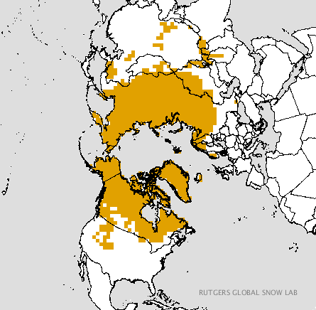

Oh and here is Rocky who is the indicator of the snow growth for these regions:
Oct 1st

Today:

WOW!!
Solar Activity – QBO (Quasi Biennial Oscillation)
The QBO is the least known factor in our winter weather pattern and the most interesting. It is the gauge of the solar activity and the down welling effects it has on our atmosphere. Last year the QBO was insanely positive causing us to lose Dec and our blocking mechanism over the NAO region for the most part so it is theorized. It has dropped significantly since then and it is something quite honestly I am not well versed on so I will not even try to discuss this here, sorry. We are in a period that is heading towards what is called a solar minimum. This means there is less solar flares and activity from, our energy source, more so our life source. Just think how insignificant we really are in the grand scheme of our solar system. You, I and everyone on this planet are a quark compared to this fluid alien system. So what does this mean? OMG so many of these questions wth!! I know but with less solar activity we have less warming of the atmosphere from space which leads to colder patterns. A German scientist Theodor Landscheidt
has been researching this and has theorized that we are heading to this solar minimum by the middle to end of the next decade. Okay great? Well with this he says that our winters will be longer, colder and snowier from the mid-Atlantic latitudes (that is us here in the Mid-Atlantic region 40 N) north. Liken to a mini ice age. Now let’s not start the global warming fight – it is not and I can discuss with any person personally about this statement. It is GCC – Global Climate Change period!!
Here is the link of his paper on this:
http://www.schulphysik.de/klima/landscheidt/iceage.htm
MONTH BY MONTH
Slow start and very strong 2nd half! Just like my 1998 soccer team baby (League and State Sectional Champions!)
December
Temperatures: above normal temps by 1-3 degrees – big fluctuations in tamps as the battle sets up between cold and warm air.
Precipitation: above normal by 1– 2” with hopefully some well-timed storms for snow
Storms: cutters, coastal
Snow: lighter amounts 2”+ – if we get the right timing with cold air then we could see greater amounts
January
Temps: Normal to slightly above for the month overall with several arctic shots lasting a few days – 2nd half of the month
Precipitation: Normal to Above normal
Snow: 6”+
Mix of storms – mix (to rain) early and then snow and ice after the mid-month time frame, coastal and maybe a Miller A as we head towards the latter part of January
*February – AO and NAO come together and the AO presses down on us at times
Temps – 2-3* below normal – cold with a couple of severe arctic outbreaks
Precip – Above Normal
Snow: above normal – 10”+
Storms: Coastals and I am calling for a Godzilla (12”+)
*the snowiest month of the winter
March – sorry but spring will be delayed as Nino weakens and the AO still pressing
Temps – 1-2* below normal
Precip: Above normal
Snow: above normal 10”+ (possible Godzilla first half of the month)
Overall Winter December to March
TEMPS – normal plus or minus .5 to 1 degree
PRECIP – above normal 2”+
SNOWFALL – above average – 40”+ – half of this could come in one or two storms
More coastal storms less frequent than the last two years but longer lasting storms. Loos like schools will be exhausting their snow days once again!
Cliff Notes:
- Slow start to winter with transient cold shots – white xmass?
- Precipitation overall is going to be above average with such a strong El Nino
- We really take off come mid-January at it lasts through March – possibly until the last week timeframe
- One or two Godzilla Snow storms
- Get the snow blower ready I say along with the firewood and the RUM CHATA drinks!
What could wrong? The unexpected:
- Nino somehow strengthens and continues to through the winter
- The Nino forcing sets up more east than modeled or thought to be – this would cause warm and wet conditions for the most part
- Polar Vortex/AO does not come to fruition or AO suppresses our storms south and east
- EPO stays negative
- Mother Nature says not this year Al Q – boo hooo!!
LASTLY>>>>>>>>>>>>>>>>>>>>>>>>>>>>>>>>>>>>>>>>>LASTLY>>>>>>>>>>>>>>
Compliments of Frank P who is the leader and president of the NJ Strong Weather forum:

AVERAGE NJ SNOWFALL COMPLIMENTS OF a forum friend:

Well there you have it peeps, my weather weeries, disciples and followers. I hope you enjoyed the read and look forward to my posts. Please inform and pass along my web address to others for some weather fun, education and many more aspects that you do know.
Have a wonderful day and let me know your thoughts or questions at any time.
Let’s see how I do this year – 3 for 3? If so I play the mega millions lottery and call it a day – hahaha!!
AL Q
