
Heat Breaks & T- REX, Tropical Cyclone Deuce for EC
Related Articles
Peeps,
HEAT BREAKS & T-REX
The oppressive heat wave that began back earlier this month will take a break for a few days. Temps will be in the lower to upper 80’s (80-87 degrees) for NNJ and NYC Metro.
Friday – Last Day of July – very sad how fast summer is going
Saturday

Sunday

Monday – WOW NWNJ in the 70 degree range!!

DEPENDS ALLEEETTT _ VERY WET over the next 4-5 days


He’s coming to a town near you Friday if he has not already this week! More SNJ and CNJ

Sunday we may have a severe threat again for the NYC Area, stay tuned.
Tropical Cyclone Deuce for EC
Peeps, this has the POTENTIAL to become a serious storm for the EC (East Coast) with possible landfall along teh East Coast in the Carolina’s (North is favored) and the Mid Atlantic North. IF you are at or know anyone at the shore from Ocean City Md up through Cape Cod they must keep an eye on this because he, Isaias (What is with these names lately?!) can be and maybe be thrashing the coast Tuesday. What else is new for 2020 right? This would be historical from what I have researched that we here in NJ may have two tropical cyclone make landfall in one months time frame and before September!!
Their is anomalous warm waters indicated by the orangy colors off the coast which will help this strengthen if he can vent, wind shear is low and dry air intrusion is limited. Three things may happen once he gets off the Florida coast.

EURO SAYS NJ COAST HUMINA HUMINA!!


This would be a low CATEGORY 1 or high end Tropical Storm if this happens. Ominous pattern setting up and I warned about this way back when. Just ask K dawg what I texted him back in late June that we may see 3-5 tropical cyclones up this way by the time Oct 31st gets her!!
Winds you ask


RAYNO SAYS – PROBLEMO!
Isaias is going to be a big problem https://t.co/l32LgooRdD
— Bernie Rayno (@AccuRayno) July 30, 2020
Not a trend we want to see – the slightest of weakening or strengthening of this storm may have big impacts on the coast
Not liking this trend in the short term of #Isaias's forecast, trough may dig a little more, but this results in a more amplified pattern that strengthens the ridge downstream (over Isaias). May be able to go further west, & a slower trough trend means later recurve pic.twitter.com/owuamftGBg
— Alex Boreham (@cyclonicwx) July 31, 2020
EURO ENSEMBLE 51 forecast models say this

Impressive cloud tops showing some strengthening

NHC says …………….GET IN THE CONE!!!!
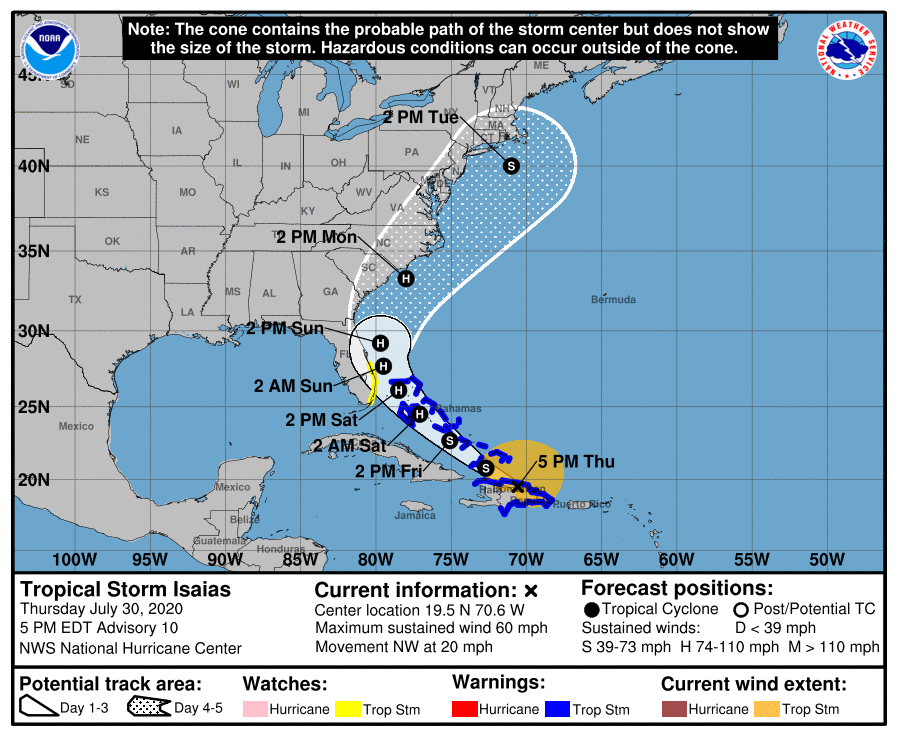
SO folks along teh coast from NC through LI and Cape COD need to keep an eye on this bad boy
