
Heavy D is a 5 and says Wagons West!! Precariously Close for Fla
Related Articles
Peeps,
First off, pray for the peeps in the grand Bahama Mamma Island and Freeport – they will experience Heavy D (Dorian’s) Category 5 wrath for not 2 or 4 hours but put that together and 24 hours plus – yes 175 mph sustained winds – MOTHER OF MERCY!!!!!!!!
Here are his latest:
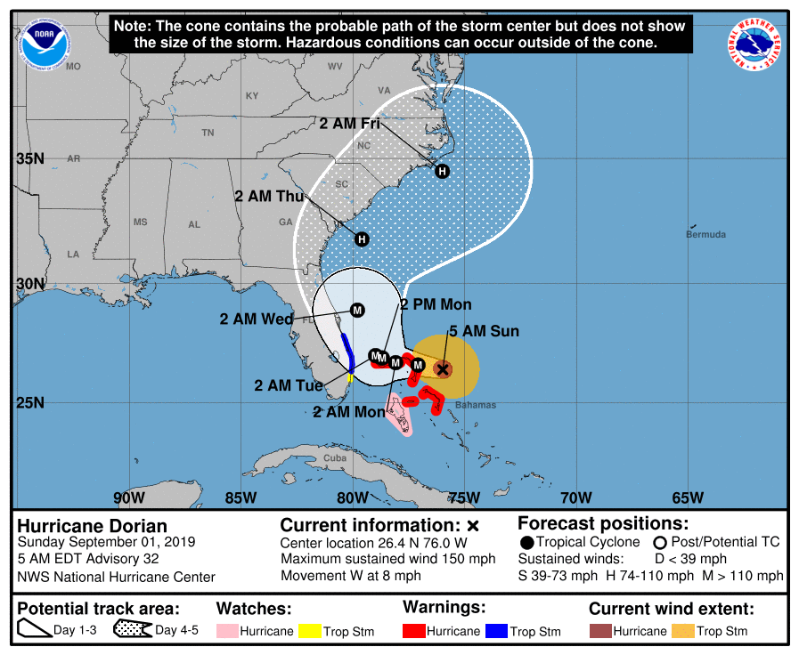
Location: 26.5°N 76.6°W
Moving: W at 8 mph
Min pressure: 922 mb
Max sustained: 175 mph
The NHC – National Hurricane Center has shifted his track further west and brings him to within about 50 miles to the coast of Fla off Port St Lucie area Monday night/Tuesday after he stalls just SW of the Grand Bahama Island. That island will be devastated and flattened to the likes we cant imagine. Here is the project path with a 150 mile variance.
“The eyewall of #Dorian is reaching the Abaco Islands. Residents there should take immediate shelter. Maximum winds have increased to near 175 mph with gusts over 200 mph. Extreme winds and storm surge will continue for several hours.”
Lyncher for you:
CAT 5 Hurricane – strongest Hcame on the scale
175 mph sustained winds that lasts for 1 minute plus
200 mph gusts
Moving West over the Grand Bahama North Islands
Here is some Livevideo for as long it is up
Florida to North Carolina
Monday late night through Thursday PM from Fla to NC progression
Tropical to Hurricane Force Winds, tidal surges (flooding), heavy flooding rains, power outages, Beach Erosion all will be affecting you.
I think it makes a landfall in the Wilmington to OBX region as a CAT 2 possibly Cat 3 Hcane but that will be seen come Tuesday night/Wednesday AM.
For us in NJ, LI Friday – Saturday Time frame – coastal folks need to keep an eye on this!!!
– we have to watch to see what he does after this trek – if the trough over SE oulls up and out before he gets here and a High Pressure system builds in then he will hug the coastal waters bring us affects.
RECAP:
Heavy D is a Category 5 with sustained winds at a devastatingly force of 175 mph with gusts at 200mph, storm surge is 12-18′ and waves 20-40′
FLA still prepare on EAST COAST from WPB up to OBX – YOU ARE NOT OUT OF THE WOODS AT ALL!!! POSSIBLE LANDFALL in the CAROLINAS as a major hurricane.
A 15 -25 plus mile wobble west as the trend has been since last night and OH POOP the East Coast of Fla is in trouble. If it 25 miles or 35 miles then they are seriously under the gun.
Here is the latest model position of teh storm off Fla – this is a 25 mile jog west from last night midnight run – disconcerting!!!

PRAY FOR THE BAHAMIANS FOR THEY ARE IN GOD’S HANDS FOR THE NEXT 36 HOURS!!!!
Update on this tonight
AL Q
