
ICE ICE BABY, Sunday Snowstorm? Solar Flare/CME, Rodent Says?, January Stats, Tonga Effects
Peeps,
Good afternoon on this first day of February:
WOW shortest month of the year
Gain 67 minutes of daylight – no these days are not longer they are still 24 hours long …well actually a bit shorter according to NOAA – here is the chart to fact check me.
https://dateandtime.info/citysunrisesunset.php?id=5128581#monthly
19 working days due to Presidents Holiday
The rodents tell us if we have 6 more weeks of winter or not!
Snowiest month of the winter for above ~ 40 latitude (parallel)
Month for Lovers…Valentine’s Day after St. Valentine (corporate America has made this another money grab be for real about this!)
Overview:
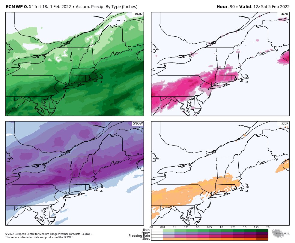
It is remarkable how this storm has shifted more south east than first modelled by about 150 miles from Binghamton with the rain/ice /snow line to NNJ in the last 36 hours and continues to waffle. This is the nature of very cold arctic air in the heart of winter, with OH CANADA being in the minus 20’s for temps (an ice box), and a deep snowpack over New England. This all bodes well for wintry weather when you have a high pressure system over Quebec that is moderately strong. February’s pattern is going to be interesting again as I posted on Sunday since this is our meteorological snowiest month of the year. There have been numerous records smashed this winter season all over the northern hemisphere on every continent so far. We have a moderate class sun flare with a CME ejection hitting earth tonight and the effects of the massive Tonga volcanic eruption from January 15th upcoming. Lets get it started!
From Sunday:
Thursday/Friday Storm
This is going to be interesting since we have another arctic front dropping in. The timing of this is crucial to what we get.
Possibly a rain to ice to snow scenario overnight. It all depends on how fast the front of arctic cold air gets here. Time will tell.
Today- possibly what we may see
It seems that the models went far south to come back north in the latest round. NNJ is in the crosshairs of an ice event even though NWS doesn’t think so and says the warm air will win out over the colder arctic air. In my experiences I have seen this happens only a few times but this was warm tropical air that is not so much the case.
Friday’s storm will have an effect on whether we have a snowstorm Sunday/Sunday night. The weaker the storm Friday the better chance for a storm Sunday. The stronger the storm then Sunday storm does not happen.
So what to expect possibly:
NNJ, NWNJ, LHV –From I 280 North and there about.
Rain Thursday night transitioning over to freezing rain and the sleet ending as snow.
How much:
Rain .25 – .45”
Freezing Rain .20 -.50 for colder far NW NJ
Sleet – .25 – 1”
Snow Coating -3”
Temperatures plunge Friday as the arctic front presses South.
Overall a Cold and Stormy Pattern possible for February. That’s all.
Record Cold and Snow – More
TURKEY DIGS OUT; CUBA’S RECORD CHILLS; + GROUND HOG DAY SNOWSTORM TO BE ENHANCED BY GEOMAGNETIC STORM — PREPARE
The COLD TIMES are returning.
The long winter is just getting started.https://t.co/iYP2piupMt— Electroverse (@Electroversenet) February 1, 2022
Solar Flare/CME
A M1 class solar flare ejected from the Sun and along with a CME (Coronal Mass Ejection) is going to hit Earth tonight and cause an effect on our weather patterns. Also this is a test for our earth force field, shield to such events. We have to see how our Magnetosphere holds up since it has been waning, losing 20% of its protective shell since 2000. It is accelerating this loss and looks to be about another 20-30% less by 2025 ish.
Tonga Effects
The VEI 5 volcano that erupted on January 15 th is now heading towards Africa or has reached it. Time will tell the effects but this video says a lot about this. Projections are that the Earth’s Southern Hemisphere will cool by about .3 to 1 degree Celsius = .5 to 1.6 degrees Fahrenheit
Rodent Says?
I bet they saw early spring in NYC (Global Warmicist will shine their lights on it at 6 AM) and winter continues in Pennsylvania.
January Stats
3.4 degree below normal – blew every prediction away
From Unc W at 33 n Rain.
Newark NJ had 28 days with a minimum 32 or lower this month…tied for 9th most since 1957…
January days with a min 32 or lower…
31 in 1977
30 in 1970…
30 in 2009…
29 in 2003…
29 in 1985…
29 in 1981…
29 in 1976…
29 in 1957…
28 in 2022…2011…1996…1994…1982…1978…1971…1965…1961…
Look at these years…..Great company of very good to great winters. February’s rocked.
She is amazing in her testimony
— Watching&Waiting (@MamaWarrior3) February 1, 2022
God Bless, be well and updates to come.
AL Q
