
ICE STORM………………………. STRAIGHT AHEAD!!
Related Articles
Peeps,
Sunday Night into Monday Early AM Recap
The Call: Periods of snow sleet and freezing rain with less than an .5” in total for all. Be careful tonight. Reports in CNJ are that freezing rain and sleet are falling.
Yes, it happened. My car was encrusted in ice last night at 10PM after dinner. Roads had some patches of ice nothing that was bad but CNJ had it worse.
Speaking of this storm is going to be historical as is the cold – ALL OF TEXAS IS UNDER A WINTER STORM WARNING!! EVEN THE GULF COAST – SAN PEDRO ISLAND AND GALVASTON!! Last time that happened according to the record books was………NEVERRRRR!!!
Last night – MY GOD the depth and breadth of this winter storm across the US is remarkable as is the cold
Today Warnings ALL THAT PINK IS WINTER STORM WARNINGS!!!! THAT GRAY – BLUEISH IS WIND CHILL ADVISORIES, THE LIGHTER BLUE IS WIND CHILL WARNINGS !!

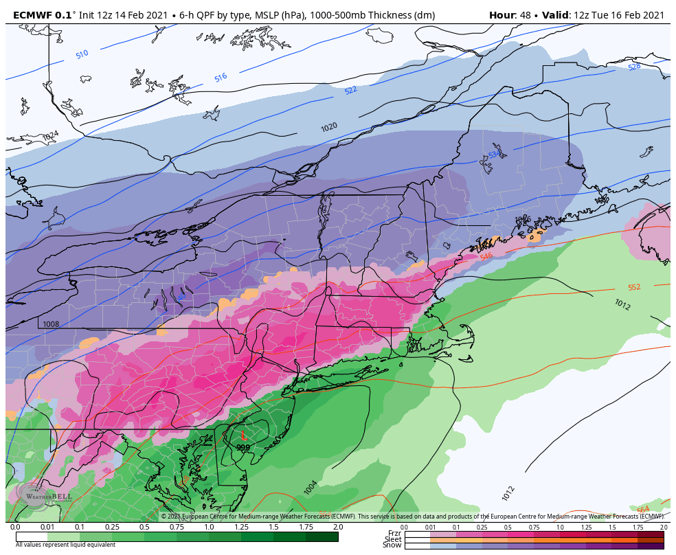
Monday into Tuesday
EURO says Vanilla Ice is coming to town!!!
Lyncher Report:
Start: Some patches of light freezing drizzle tomorrow morning break out over NNJ around 9AM. Main bulk of the storm comes in around 6 -7PM. It will be mostly sleet at the start nd snow (mix) but A LOT of freezing drizzle and rain for about 8 hours maybe longer in the mountainous regions of Western Bergen County, Passaic, Morris, Sussex, Warren and Hunterdon Counties’ get pounded. Probably until about 8-9AM.
LHV Counties of Rockland, Northern Westchester, Orange get pounded as well.
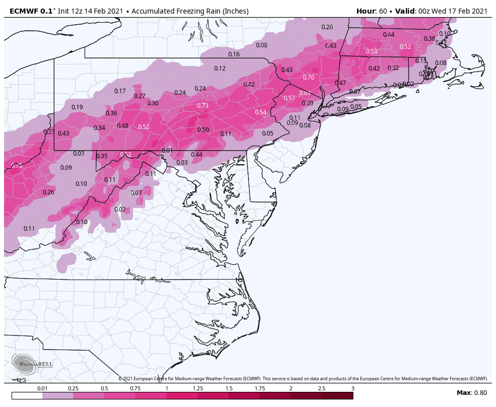
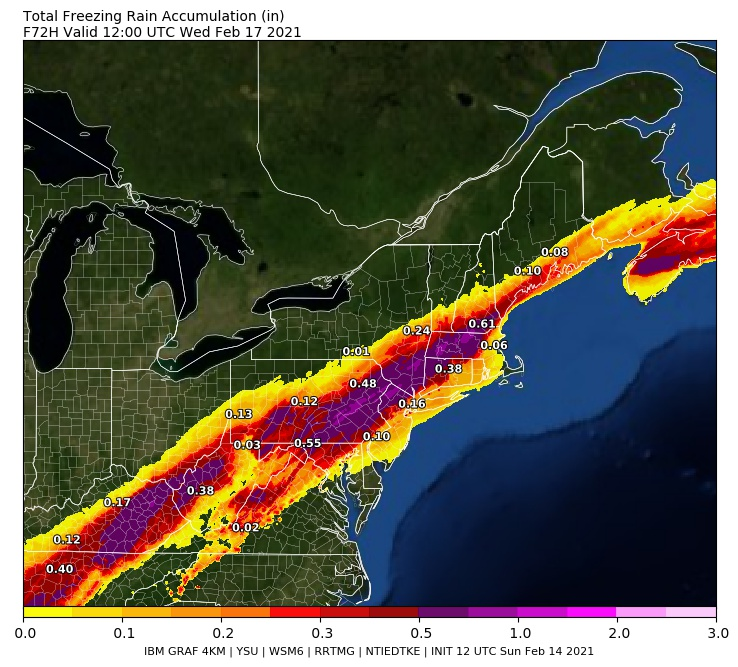
Total Ice Accumulation (Accretion)
NNJ – .15” – .25”
NW NJ, Northern Rockland, Northern Westchester, Orange -.25” – .75 (highest terrain)”
Power Outages are likely in these regions!
Storm will transition over to rain Tuesday but not before the damage is done in these areas N & W of NYC.
Yesterday I said this: This is very fine line so far between an all-out ice storm for the NNJ, NYC Metro, EPA and LHV regions or a snow to ice to rain storm. So, I say to you folks play it cautious, get prepared and hope for the best. Be prepared and not scared my weenies
(3rd time is a charm for the correct spelling of my super snow weenie – N Klas!!)
For thes areas in NJ – other areas should be put under this as well stated abouve
Ice Storm Warning
URGENT – WINTER WEATHER MESSAGE
National Weather Service Mount Holly NJ
315 PM EST Sun Feb 14 2021
NJZ009-010-PAZ060-101-103-105-151100-
/O.NEW.KPHI.IS.W.0001.210215T2300Z-210216T1500Z/
Hunterdon-Somerset-Berks-Western Chester-Western Montgomery-
Upper Bucks-
Including the cities of Flemington, Somerville, Reading,
Honey Brook, Oxford, Collegeville, Pottstown, Chalfont,
and Perkasie
315 PM EST Sun Feb 14 2021
…ICE STORM WARNING IN EFFECT FROM 6 PM MONDAY TO 10 AM EST
TUESDAY…
* WHAT…Significant icing expected. Total ice accumulations of
two tenths to three tenths of an inch with up to one inch of
snow and sleet.
* WHERE…Portions of northern New Jersey and east central and
southeast Pennsylvania.
* WHEN…From 6 PM Monday to 10 AM EST Tuesday.
* IMPACTS…Power outages and tree damage are likely due to the
ice. Travel could be extremely difficult. The hazardous
conditions will impact the morning commute on Tuesday.
Thursday into Friday – Still on the table for this storm and we’ll see how things progress but it will most likely be a winter weather storm.
We will relax next weekend as currently modelled for about 7-10 days and we’ll go from there as we head into March. Will it be warm? White? Wet? The Polar Vortex is taking another hit and is weakening and the shortwaves are lengthening which allow things to get extreme during this transition month.
Temps have trended colder

Time will tell.
Mid point of the month and we are running about 4 degrees below normal here in NNJ. What will the 2nd half be like?? Normal? Abby Normal or Above Normal?

Enjoy your Lover Day and update to come.
Al Q
