
My Call last week, Bookened Snow Storms?, 83 rewind for Xmas?
Related Articles
Peeps,
My Call last week:
All Sections
Dec 9 at 10:47am (check the date!)
Folks,
I am going to post this here to spread the good news of this exciting upcoming pattern that I spoke about at our meeting on Nov 30th. Has it been delayed, yes but that happens with the transition of seasons especially fall into winter. But have no fear, Mr. Mugno (Al Q) is here!!
Sunday night into Monday we can see 1-2″ of white gold as we call it, aka snow
Then at the end of the week, Big Momma is going to bring us some more goods of white not wet!!! And it is perfect timing for a very special day. The day I was brought into this world.
Bookened Snow Storms?
Herse a write up from a pro met friend on the 33nrain wx board:
Thought I would show the importance of maintaining the suppressive higher heights in Canada throughout its trip eastward.
Below we have yesterday’s 12Z run. What I want to point out is that we are seeing a weakness above our closed low being generated by troughing/vorticity. The result is we see a quick jog north of our closed low.
HOLD ON!!!!
This is VERY IMPORTANT NEWS HERE:
But on our overnight run we see this. No weakness as the heights remain strong. So we are not seeing that quick shift to the north as the prior run.
Here is the resulting snowfall map. Needless to say it isn’t hard to see the differences. We are seeing heavier snows much farther south and to the coast.
Now I am using 4-day snowfall maps above to try to pick up on both the initial surge northward in front of our closed low as well as our developing east coast system (if it plays out the way that is seems to be favored at this time). What I would like to discuss is the initial surge northward of moisture/precip in front of the closed low as it pushes into the Midwest. What we will see is overrunning snows develop in the deep enough cold air. There is a good chance modeling is underplaying the potential snowfall and its southward extent from this. As several have pointed out prior, models many times will underplay the CAD (cold air damming) in front of this system in the longer ranges. Which means, as we near in time we will very likely see the projected snow/ice shifting southward along with the strengthening CAD on the models. Given the nature of the 50/50 (strength and positioning) there is a chance that modeling may very well be underplaying the CAD significantly. If this is the case don’t be surprised if we see a significant shift southward of the snow and ice as we near in time. This stronger CAD, if we see it, will also play a part in what we see with the transferring low from the primary in the west to the secondary to its southeast. So along with a stronger CAD feature we should also see a shifting of the transfer to the south as well.
Now we shall keep an eye on this for it is moving up to the Thursday night into Friday scenerio!!

Here is the POTENTIAL this storm may have:

It would be the first Barney Alert of the season but we’ll have to see.
83 rewind for Xmas?
This is very cold and stormyish pattern we are hitting and the first week of winter thorugh until the first week of January I’d say before we break it down to reload it about a weekish later – time will tell but looka this – to a weather weenie this is drool worthy!
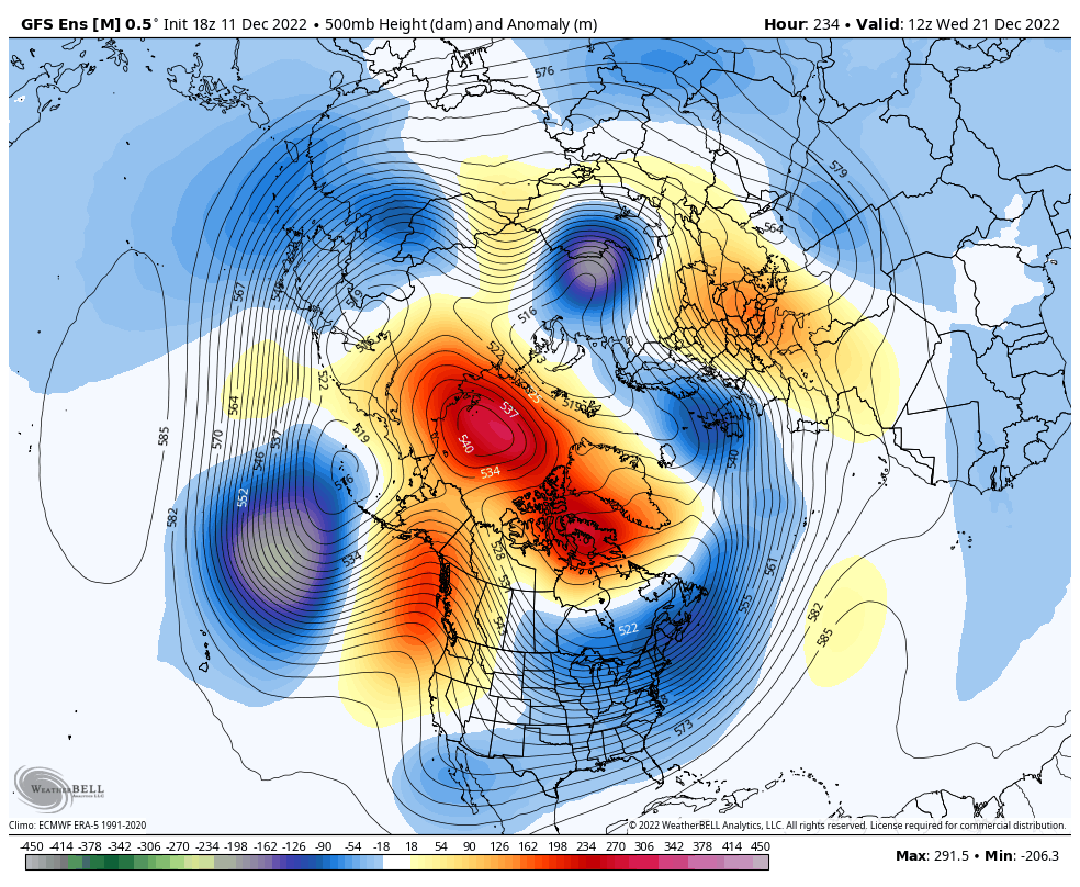
The cold being portrayed next week is on par with teh great arctic outbreak of 1983 before xmas, it was -1 in Paterson on Xmas Day!!!
Wed. morning lows

Have a great snowy night and I measure .5 here in Hdale so far!!
God Bless and keep the faith in him for he will guide you along, he will never leave your side!!
Al Q
