
NOV 1, 2020 – Back to the VIDEO – Forecast Verified Overall, WIND ADISORY, Winterlike cold MONDAY & OUTLOOK, Indian Summer by Friday
Related Articles
PEEPS,
NOV 1, 2020 – Back to the VIDEO – Forecast Verified Overall, WIND ADISORY, Winterlike cold MONDAY, Indian Summer by Friday, LC WINTER Outlook
LC WINTER Outlook
BOOM FROM LC – aka Larry Cosgrove Pro Met
MONTHLY FORECASTS
NOVEMBER
Most of the analog years present a fairly standard +PNA signature with a warm West vs. cool Central, East alignment. But a recurrent issue is that all model guidance is solidly warmer than normal over most of North America. Given that the comparison test looks almost exactly like the same September 1 – October 16 of this year, I kept the temperature forecast very close to the twelve-year mean.
If shortwave injections into the Mid-Continent mean trough are as strong as what is shown now over the northern Pacific Ocean, potential for high wind events will be high from the Rocky Mountains into the Mississippi Valley and Great Lakes in November.
DECEMBER
A more difficult forecast, since there is a prominent warm-up across the Old South and Mid-Atlantic regions which may not be viable. Note the positive height anomaly in the -NAO position (Baffin Island and Greenland) which in many cases could be construed as a block that triggers southward deviation of the jet stream. That said, the numerical model guidance is very aggressive in presenting a Southeast ridge. That feature is normally linked to very warm conditions east of the Rocky Mountains. The gradient set-up between recurrent storms over MT and WY vs. the ridging implies repeated high surface wind potential from the Great Plains and Texas into the Corn Belt.
Caveat: Should the high-latitude anticyclone be the stronger of the two ridges, temperatures will be much colder across the Midwest and Northeast than what is shown here.
JANUARY
A much colder outlook than the previous attempt. The presence of ridging in the -EPO, -AO, and -NAO positions normally favors relocation of the cA vortex at 500MB into Ontario and James Bay. Indeed, with the core negative height anomaly aloft centered roughly over MN and W ON cold pooling will probably relocate to between the Rocky Mountains and Appalachia. The surface storm track may stay inland over the Piedmont and Atlantic Coastal Plain, so the major cities may have cases of rain and not snow. All things considered, there will likely be some very wintry moments in the Midwest and Great Lakes. The western states seem warmer and drier than normal outside of a few frontal passages along the Pacific Coast.
Caveat: It would not take much, with the widespread ridging at higher latitudes, to turn the Eastern Seaboard into a winter wonderland as we start 2021.
FEBRUARY
Similar in many ways to the January upper air pattern, but with more extensive cyclonic curvature and cold air through the eastern two-thirds of the nation. If there is going to be a major snowstorm along the East Coast, it probably will be in February. Note the stability of the blocking ridge complex above the Arctic Circle.
Caveats: If ridging builds into British Columbia, we could see cases of severe cold and more frequent frozen precipitation from the Great Plains to the East Coast. Conversely, if the blocking signature is weaker, there may be some merit in the very warm outlooks posted by the CFS and ECMWF series.
MARCH
Yet another example of a back-ended winter forecast. Note that there is very little change in high-latitude ridge position and strength. In theory, if this forecast verifies, abundant snow in the Great Lakes, Mid-Atlantic, and New England could help to maintain substantial cold to the right of the Continental Divide.
Caveats: The very warm numerical models continue to concern me, and are a reason that I moderated temperatures somewhat from the Mid-Atlantic to the Eastern Seaboard.
Curiously, all analog and modeled guidance suggests a turn to much warmer weather nationally as we enter April. But March should be cold.
SUMMARY
Snow cover in the Northern Hemisphere does not look like anything special now. (This is DEAD WRONG!! Look at the map below!) But given time, and ridging spaced about the North Pole and Arctic Circle, the strong polar westerlies acting in concert with a La Nina signal should produce vigorous storms in the middle latitudes. The dryness in the middle of the continent could limit snow in the Great Plains and Rocky Mountains. But if the analog predictions verify for the winter months, there will be a great deal of snow in the Great Lakes and Appalachia. The best odds on snow impacts along the Interstate 95 corridor appear to be for February and March. The two most active storm track threats: Alberta Clippers and “Miller B” Hatteras Lows (one of which could be a memorable winter storm).
A colder winter, overall, than the five most recent DJFM period
ME:
These SST are very interesting and are going to give forecasters a very trying time this year. We await Isotherms winter dissertation in the coming 2 weeks. Where the HP sets up over the warm blob remains to be seen. That is a cold Southern Pac. Indian Ocean looks to be settled in Central to Eastern region.
Enlarge this image Click to see fullsize


North American Snow – LC is DEAD WRONG!!

Winds manana
.WIND ADVISORY IN EFFECT FROM 6 AM TO 6 PM EST MONDAY...

* WHAT...Northwest winds 20 to 30 mph with gusts 45 to 50 mph.

* WHERE...Southeast New York, northeast New Jersey, and southern
  Connecticut.

* WHEN...From 6 AM to 6 PM EST Monday.

* IMPACTS...Gusty winds could blow around unsecured objects.
  Tree limbs could be blown down and a few power outages may
  result.
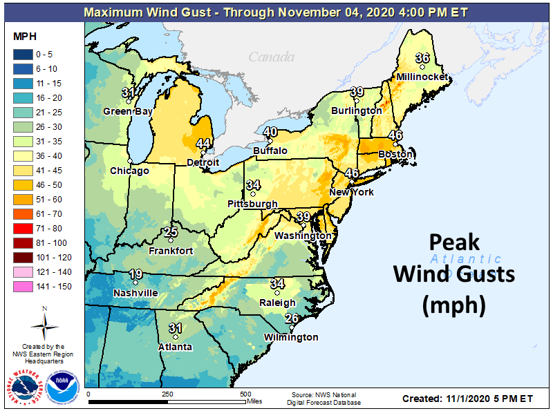
Forecast verified Map

Forgot to put the Wind Chill Map on the Vid ARGGHH!
Monday Morning

Tuesday Morning

Enjoy and have a great night.
AL Q
