
TREND IS OUR FREIND!!! Snow Prince,,,,,,,,,,,
Related Articles
Peeps,
As I said to MANY who were asking via text yesterday and today – so what’s happening with the storm? I said wait until this afternoon, not making a call – did not like the trend yesterdays , even tough I have been through this dance MANY times tracking coastal storms, Nor’easters. The trends were not good yesterday but last night we had a skull session Zoom call – Frank the P, Zoo, Mugs 9me) and Alex with Scotty the Hound dog in the winds. We dissected every model run for one hour with teh NAM our main focus adn why you ask? Cause the NAM does very well sniffing out Nor’easters and their track at the 500millibar level which means everything. And we saw a definitive shift and positive trend occurring but had to temper expectations not to jinx it.
Remember my last post 1/25 Tuesday??
What is possible:
-
1.Heavy Snows – 6″ plus at this time – models spit out 2 – 3x this amount but being conservative I am – don’t want to jinx this!! Right………… Snow Princess and Queen!! We need a Snow Prince right? Geeb? Clover? Asplint? Councilor?? GBach – Brando doesn’t fit it, well his wife would say.
-
2. Heavy Strong Winds and Gusts -30 mph plus
-
3. Moderate to possible Major Coastal Flooding – astronomical high tide to boot – waves 20-30′ plus
-
Multiple High Tides
-
-
4. Power outages
-
5. Transportation stoppage/grounded
-
6. Duration 24 hours minimum plus
-
7. Booze, profies, BEM, firewood -All sold out
I have seen these before and they end up being logged into the KU books at the National Weather Service.
This one has the markings and the chance to be one.
UPDATES: any changes will be made tomorrow afternoon – there is bust potential here for some parts of NNJ
1 CHECK
Asplint get the crew ready my man long night and day ahead
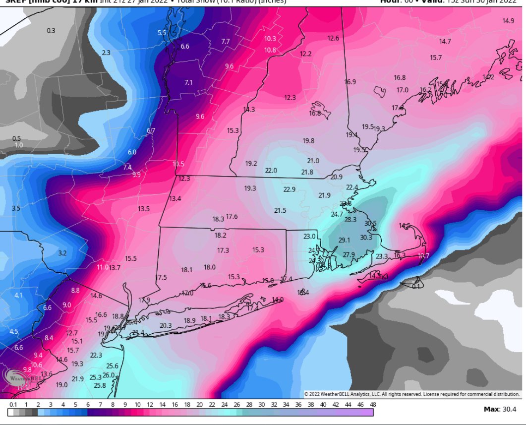
SNOW 4-10″NYC Metro, Passaic/Bergen County over to NYC, LHV
CNJ 6-12″
SNJ coastal sections 10 -16″ Blizzard conditions
LI 10-24″ that’s right one to two foot
CT is the area winner as well with 10″ – 2′ in Eastern CT – I believe LI and Eastern CT go to Blizzard warnings tomorrow from New Haven East and from CLI east.
2 CHECK
Wind gusts 25/30 mph plus
Coastal NJ, LI and CT 35-45/50 MPH plus
3 CHECK
Moderate to possible Major Coastal Flooding – astronomical high tide to boot – waves 20′ plus
-
-
Multiple High Tides
-
Beach Erosion
-
4. Power outages
Along the coast and on LI and CT possible
5. Transportation stoppage/grounded – not in NYC Metro
6. Duration 24 hours minimum plus – about 12-16 hours in duration
7. Booze, profies, BEM, firewood -All sold out – Tomorrow it will happen
I have seen these before and they end up being logged into the KU books at the National Weather Service. CT to BASTAAN yes!!
This one has the markings and the chance to be one. – THIS IS STILL POSSIBLE for NYC!!
Timing Late Friday night around 10/11PM Ending Saturday mid afternoon/early evening
Maps:
Here’s your cluster peeps in black circle – amazing balls!! THESE COME TRUE THEN WE GO TO 1′ EASILY FOR NNJ AND NYC METRO.
Enlarge this image Click to see fullsize

PRECIPITATON SHIFT ,6″ OF LIQUID = 6″ OF SNOW AT 10:1 RATIO – THIS WILL SNOW AT 15:1 OR EVEN 20:1 = 9 ” TO……1′ POSSIBLY

HILARIOUS:
Keep trending west !!!! @JimCantore @dmacbolts10 @MikeMasco pic.twitter.com/YRgMdFesDf
— Mike Trout (@MikeTrout) January 28, 2022
A GRAET SNOW MAP


AND THE CROWD CHEERS IT!!
THIS IS INSANE OR WOULD BE THE TOP END SNOW TOTALS IF IT HAPPENS
START AT ABOUT 6:00 am NNJ A DURING THE COMMUTE – THIS SI CALLED TEH PRE – MAY MAKE THE COMMUTE SLICK UP TO AN INCH – maybe a delayed opening?? This could trend stronger and faster as well. Leave a few extra minutes.

This is not the main storm.
SNOW PRINCE
Has been crowned …………………A student of mine that I also coached back in the day in Allendale Middle School for teh Brookside Buldogs … None other than……………………
GREG ASPLINT!!!!
Peeps update in teh afternoon if need be and overnight runs starting in 5 minutes and if there is any indication of what we have seen today and the recon data flights that the Hurricane Hunters are making for this storm that is how serious and worried they are then it may continue to come back and make history.
HUNGA TONGA VOLCANO = global cooling incoming – worst volcanic explosion in modern recorded history!!
Be well, enjoy.
Al Q
