
Vanilla went Nothingella, Warning Level Storm R/F, Disaster in the South
Related Articles
Peeps,
Last night storm stayed warmer as the LP system tracked well to our west allowing warmer air to infiltrate the region you know like what is happening to our country at all organization sectors since WW2?
Here are the stats on last night storm – Trace of ice here in NE NJ, I reported as well.
************STORM TOTAL ICE (AT LEAST 0.00 INCH)************

LOCATION                TOTAL      TIME/DATE  COMMENTS
                          ICE       MEASURED
                     (INCHES)

CONNECTICUT

...FAIRFIELD COUNTY...
  DANBURY AIRPORT        0.08   400 AM  2/16  ASOS

...NEW HAVEN COUNTY...
  MERIDEN AIRPORT        0.11   400 AM  2/16  ASOS
  GUILFORD                  T   404 PM  2/15  CO-OP OBSERVER

NEW JERSEY

...BERGEN COUNTY...
  TETERBORO AIRPORT         T   845 AM  2/15  ASOS

...ESSEX COUNTY...
  CALDWELL AIRPORT       0.01   700 AM  2/16  ASOS

...PASSAIC COUNTY...
  BLOOMINGDALE              T   800 AM  2/16  TRAINED SPOTTER

NEW YORK

...ORANGE COUNTY...
  MONTGOMERY AIRPORT     0.36   700 AM  2/16  ASOS
  GREENVILLE             0.30   800 AM  2/16  TRAINED SPOTTER
  1 SE THOMPSON RIDGE    0.25   700 AM  2/16  TRAINED SPOTTER
  WARWICK                0.20   945 AM  2/16  PUBLIC
  MONROE                 0.06  1100 AM  2/15  TRAINED SPOTTER
  WEST POINT                T   745 PM  2/15  TRAINED SPOTTER

...SUFFOLK COUNTY...
  PORT JEFFERSON            T   517 PM  2/15  TRAINED SPOTTER
  ISLIP AIRPORT             T   700 PM  2/15  ASOS

...WESTCHESTER COUNTY...
  SOMERS                    T   930 AM  2/15  SOCIAL MEDIA
  WHITE PLAINS AIRPORT      T   830 AM  2/15  ASOS
Thursday into Friday – this a Winter Storm Warning snowstorm hands down peeps. Gas up the blower!
This trend is our friend. It is trend colder and snowier – SNOW QUEEN and PRNICESS unite!! It looks to be a snow to possible ice storm overall with more snow N&W on NYC and time will tell. These are the trends we like to see as snow weenies. Barney Alert for this one folks – boy he has been busy these last 3 weeks around here.
At this time what we can expect and this will change it always does!!
Preliminary Start time Daybreak Thursday morning 8-9 AM ish
Worst part between 10/11AM until about 12-1AM – some pretty intense snow bands during this period of 1-2.5″ per hour rates possible
End Time Friday 6-8AMish maybe a bit longer light percip of wintry mix of snow, sleet and freezing rain
Snow totals 4-8” NNJ, Ice –Sleet then freezing rain to end about another .25” of these combined
NYC Metro 3-6” then sleet, freezing rain about .25”
CNJ – 3-6” and same as NYC but may end as plan rain
Here are the maps:

Maps with higher snow ratios which may happen with some intense banding.
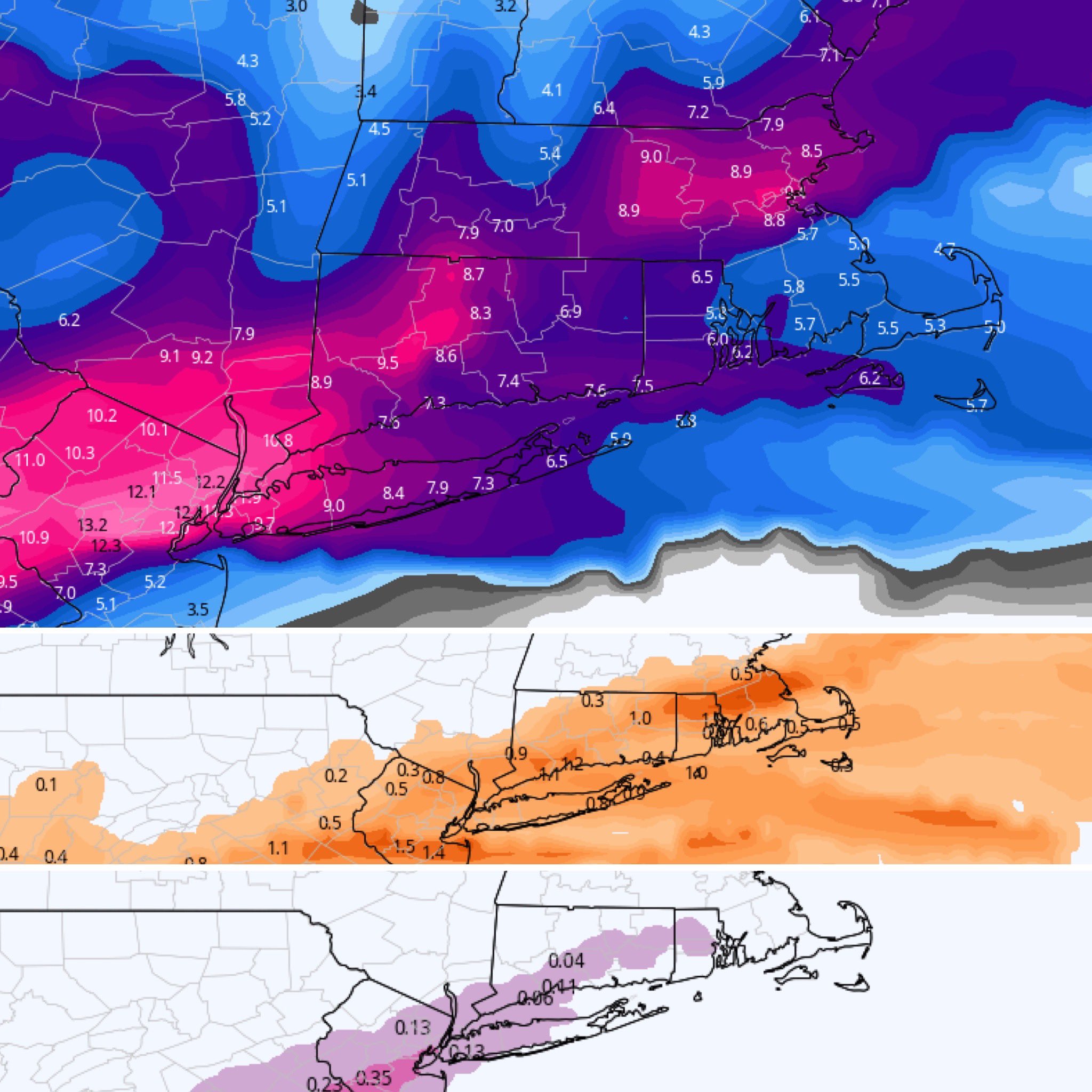
Orange is sleet
Pink is freezing rain
Disaster in Texas, Oklahoma, Louisiana, Arkansas West VA North Virginia
Power outages galore and the temps last night as we were all sleeping warm n cozy in our beds hit below zero and teens for a majority of this region. I texted to my peeps Ralphy F – he’s the best, Bach squared, and some others that it was colder in NOLA and 50 miles into the Gulf of Mexico than in NNJ last night with the wind chills!!!
People are sleeping in their cars, no heat, no running water, rolling blackouts from North Dakota to Texas covering 12 states and why?? Well many factors but snow and ice and extreme cold are causing the “Green Technologies” to fail and not work. Wind Mills are frozen in place, solar panels are covered with snow and ice and some have cracked under these cold conditions. Not a good recipe right now.
BARBARIC COLD for this region last night
Power Outages = BAD!
Enlarge this image Click to see fullsize

WOW 2015 was the last time we saw something like this

UM this is nuts yuo can hear the electricity humming
MY GOODNESS! Look at this video from Chris Fitzmorris in Kenner 😳😳😳😳 @wdsu pic.twitter.com/TOXx9qptYb
— Christina Watkins (@CWatkinsWDSU) February 15, 2021
All the tail lights on are people sleeping their cars
Texans are sleeping in their cars as we suffer the stark realities of the #GreenNewDeal. 30% of our power comes from renewables now – and it turns out the don’t work in the ice and snow. We shutdown our gas fired plants and now we live in the 3rd world.pic.twitter.com/BSqbX2sIqG
— @amuse (@amuse) February 16, 2021
@GovAbbott (in office since 2014) failed preparation or.. Wind mills bought w/o antifreeze and supplies only 20% of energy. Doesn't want to join other states energy grids and pays more for costly energy. TX cities burn bright while residences are dark. https://t.co/J5GSHoe0jX
— person (@holmanland) February 16, 2021
From LONG TERM Scientists climatologist David Dilley on the question from my NJWO group president who asked him about this winter and the upcoming winters:
“Pretty much as expected Al. Great to see you received a lot of snow, very little more to the northeast. Our cottage in Maine only has about 10 inches on the ground, most storms have been snow changing to rain.
Rest of the country is getting pounded, worst freeze in Texas in decades, also the story in Europe, parts of Asia.
The weak La Nina seems to be briefly be breaking the Arctic Vortex dam, but short lived. This is however a very good sign that global cooling is setting in. I do expect a moderate to strong El Nino during the 2022-23 winter, will be very stormy with lots of snow in the northeast with big northeasters. Also a bad freeze for Florida.”
