
Battin’ Down the Hatches, NAM Punked, Lee
Related Articles
Peeps,
NAM Punked – stupid model!
The North American Model has a wonky run last night but it did cause a stir in the Wx community. We are not going to see effects from here at this time wheew in a big way from 5 days ago. She will decay over the south east but hurrciance force winds will stretch from the Fla Keys to Atlanta!! She is going to run up the spine of Florida and cause catastrophic to severe damage as the whole state and coast to coast will be engulfed in CAT 4 and 3(as she weakens as she chugs North) and possibly 5 winds at landfall in S FLA. One person here at work well she was downgraded – umm yes but 145 -150 mph winds is good??? I dont get people! (Answer was well it is better than 175 ??, Its like 30″ of snow or 36″ wth??
Hcane force winds up through Hotlanta!

Latest Recon data shows here winds back up to 150mph – she just finished her ERC (eyewall replacement cycle) so she can wipe of the debris that she sucked up and get ready to intensify and whack Fla.
By the way the winds at a CAT 5 are like an EF 4 tornadao in the NE Quadrant wall!
Water temps where she will run through and take her last gulp

Track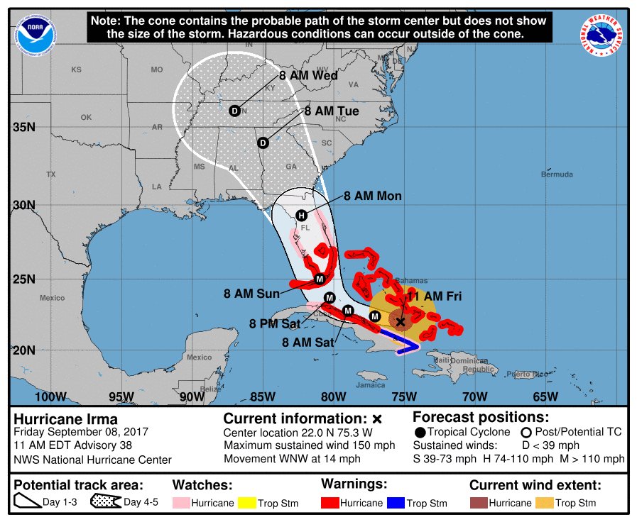
Wave height 30-40 plus feet Miami !!

She is cruising just North of Cuba and once she is done she will hit the 86/87* bath water so she can have on last chug of energy before she makes landfall somewhere in SW Florida.
http://www.ssd.noaa.gov/PS/TROP/floaters/11L/imagery/rbtop-animated.gif
Jose looks to now pass north of the leeward islands which will spare them from another direct blow of a Major Cat 4 hcane but will get tropical force winds of 60-80 mph.
So we wait, watch the radar to see both storms paths and pray for all those is their way.
Lastly here comes Lee another trop cyclone that may turn into another Major Hcane. YIKKESS!!

Updates to come.
Sorry if I caused a stir amongst you last night but when you see a run like that and you see the upper air pattern set up it is sends up the red flag.
AL Q
