
Friday Coater Verified, SB 2014 Redux – WSW FLY!!
Related Articles
Peeps,
I BIG SHOUT OUT TO ONE OF MOST ARDENT WEENIES!!
N KLAUS – She has been with me from the beginning and follows me like my dog did (only when she wanted to eat LOL)! Man’s best friend and my most loyal follower – here’s to you on the National Weatherperson Day!!!
Friday Coater Verified
Nailed it peeps – snow icy mix , Western Bergen County west and North had a coating to 1″ recorded in most locals – put another one in the books.
Three peat incoming since last Monday – well missed that one but we are hot right now so LET’S GOOOOOOOO!
SB 2014 Redux – WSW FLY!!
Anyone remember 2014 Super Bowl Storm?? NJ held this game and the fat bastard Governor Krispy Kreme well Chris Christie was his name and eating donuts was his game! Started snow at 10PMish just after the game was over and we woke up to 6-8″ of white gold and all weather forecasters held off by their station managers commands until the 11 o’clock news update before they released the Kraken?? Yes, I sure do fake media back then too!
As I said last night with a post we are seeing a 3-6″ possibly 6-10″ storm watch the 5 o’clock news hams start harping on my call, wannabies they are. Who’s your weather daddy??
Maps please – NAM goes bonkers on us says 6-12″ area wide for 1st Cuz in Middletown along with my BFF Arooch Boyj, Paulie in Township, Chives in Hamden at the QU, PB in the Willy, and say it ain’t so Joe and Vas in the Valley! Let’s not forget K dawg and his posse!

GFS is 3-5″meh and it has been struggling with this storm – late to the party – did get paid got in a fight – Kiss Me Deadly anyone??

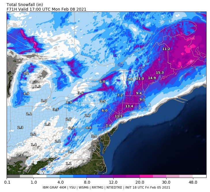
IBM model says hello Barney!!
NWS says a double down on our guy Al Q

EPAWA Says hi AL Q

I think this has room to tick about 25 more miles NW. There si still tomorrow runs to go through as well but yuo get teh idea.
Lyncher report:
Time start: 3-5AM SE to NE
End time: 2-4PM
Amounts:
Use the map above by EPAWA .
WSW = Winter Storm Watch
URGENT – WINTER WEATHER MESSAGE
National Weather Service New York NY
329 PM EST Fri Feb 5 2021Northern Middlesex-Northern New London-Southern Fairfield-
Southern New Haven-Southern Middlesex-Southern New London-
Eastern Passaic-Hudson-Eastern Bergen-Western Essex-Eastern Essex-
Western Union-Eastern Union-Southern Westchester-
New York (Manhattan)-Bronx-Richmond (Staten Island)-
Kings (Brooklyn)-Northwestern Suffolk-Northeastern Suffolk-
Southwestern Suffolk-Southeastern Suffolk-Northern Queens-
Northern Nassau-Southern Queens-Southern Nassau-
329 PM EST Fri Feb 5 2021…WINTER STORM WATCH IN EFFECT FROM LATE SATURDAY NIGHT THROUGH
SUNDAY AFTERNOON…* WHAT…Heavy snow possible. Total snow accumulations of 5 to 7
inches possible.* WHERE…Portions of northeast New Jersey, southern Connecticut
and southeast New York.* WHEN…From late Saturday night through Sunday afternoon.
* IMPACTS…Travel could be very difficult.
PRECAUTIONARY/PREPAREDNESS ACTIONS…
Monitor the latest forecasts for updates on this situation.
Could be a 6-10″ if it keeps trending.
See you manana – gas up the blower peeps we gonna need it!
AL Q
