
October 28, 2020 – OLD SCHOOL & ZETA is a deuce, Trop Storm Warnings from NOLA to Va, White Gold still on the radar and ya’ll heard it here 1st – I hope!!, Frigid Fri and Sat Night and the Mon into Tuesday with Lake Effect Snows, COVID Stats are skewed
Related Articles
PEEPS,
Have to go Old School again – The Queen pleaded with me to do so LOL!
ZETA is a deuce
ZETA strengthened to a CAT 2 in 8 ours from a weak CAT 1 with 110 mph winds and gusts to 125mph as it made landfall over NOLA – my insider intel, YUGE TY to JM who gave me updates and bigger thanks to his big Sis for hooking me up with JM in a thread.
Check out these waves from Hurricane #Zeta on an oil platform in the Gulf of Mexico. This specific rig is south of Louisiana, and was near the eyewall of Zeta. They recorded wind gusts exceeding 150 mph, and waves over 50 feet!
📸: Brian Stout pic.twitter.com/yF8D4gKaJo— Jennifer Lambers ⛈ (@jnlamberswx) October 28, 2020
NEW VIDEO — Water rushing over Highway 56 in Cocodrie, Louisiana. Video: Nicole Marie. @WGNOtv @HankAllenWX @BrookeLaizer_Wx @StormHour #HurricaneZeta #Zeta pic.twitter.com/zkXx0ftvID
— Scot Pilié (@ScotPilie_Wx) October 28, 2020
Surge is 7-11” ala Sandy – we know what happened here from that biag (picture of Sandy the Squirrel)

Trop Storm Warnings from NOLA to Va
This is crazy but true for Rocktober. Winds of tropical force cover the entire projected forecast due to its forward speed of 26 mph. It’s trucking along and will pick up speed once it hits the Tennessee region.

RED colors is TROP STORM WARNINGS!!

White Gold still on the radar and ya’ll heard it here 1st – I hope!!
LYNCHER REPORT:
START: ATFernoon Thursday
RAIN: 2-3″ area wide
SNOW: Elevations but the changeover happens mid-morning Friday
WINDS:10-20mph gusts to 25 mph
Yes we are still on track to see white gold – elevation regions get 1-3” PB, Magretto; Britt, Marky Mark, Guerci land and Rich and Carol 2-4” is a good call – the NYC Metro sees flakes with maybe stickage to car rooftops and colder surfaces.
Here are the models
EURO – off the WxBell paid site (by my hard earned pennies as a teacher!!)

NAM

SNOWFALL AMOUNTS:
EURO

NAM

Rain Amounts – wet

Growing season end Friday night – no more mowing the lawn and plants are done till next spring!
This is a record and this is not due a warm climate but other factors like the life of our planet….TEH SUN!!
173 days between snows in NNJ and possibly NYC – that is a record the average is March 18th to Dec 5th ….262 days!!!! Literally a whole season difference.
Frigid Fri and Sat Night and the Mon into Tuesday with Lake effect Snows
Temps in the 30’s and 20’s Friday and Saturday nights


Monday highs looking to be around 40 and nightly lows in the 20’s!!


COVID Stats are skewed
Watch the Tweeted Video from my new favorite news network OAN!!! Nonpartisan and not run by a billion dollar corporation who have an agenda!
Looks like CDC reduced your fake 270K and its own incorrect 210K fatality numbers.
So sad that you spread disinformation about #Covid_19 deaths.
Seek help! pic.twitter.com/iLbsHrYUJc
— 𝕊𝕜𝕪 (@SKYRIDER4538) October 22, 2020
SNOW COVER FOR North AMERICA IS OFF THE CHARTS!!
RED LINE IS THIS YEARS SNOW COVER>>SO FAR!!!
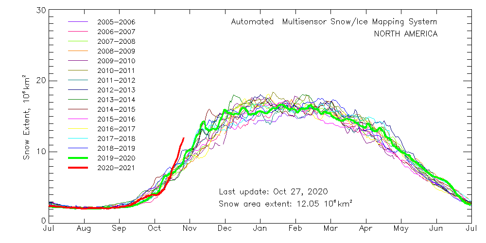
Over the years – hey AL Gore you see this?? LOL 20 years ago you said we’d never see snow again in the USA starting in 2012.. then pushed it to 2016…. then kick the can (as all politicians due) to 2020 – stick to being a leech, scum sucking politician as a massive majority of them are – ALL sides and parties!!
Updates to Come.
AL Q
