
Some more white for Monday, Warm Up, Sun Angle, FRANKLIN!
Related Articles
Al Q
Peeps,
HAPPY BIRTHDAY RAY!! My man Ray M turned the BIG 5….0 and made it to the half century mark. Been a co-worker, AL Q weather weenie and good friend. Wishing him the best and many healthy, and happy years ahead! Maureen’s video was amazing!
Speaking of good friends – Pauly and Dawn G was the place to be, they were rocking it fresh and organically on a cold winter Saturday night. Great to see them and catch up. Her padre, God rest his soul, started the first organic foods company back in the early 2000’s serving NYC resties. It has grown tremendously as Paulie G has taken tehhelm but Dawny’s Pops and Jimmy G were on this year’s before many were. Why? The foods we eat between the outer walls of the supermarket food stores are garbage, processed, NG for the human health. Dr. Trokhan the magician of orthopedic surgery explained this to my son and I when he hurt his hip back in 2017. Here is a video on GMO’s and what “they” (US Govt and Big Pharma/Ag) are doing to our foods.
An hour 20 minutes of worthwhile information you should share with family and friends
Anyway, onto the weather!!
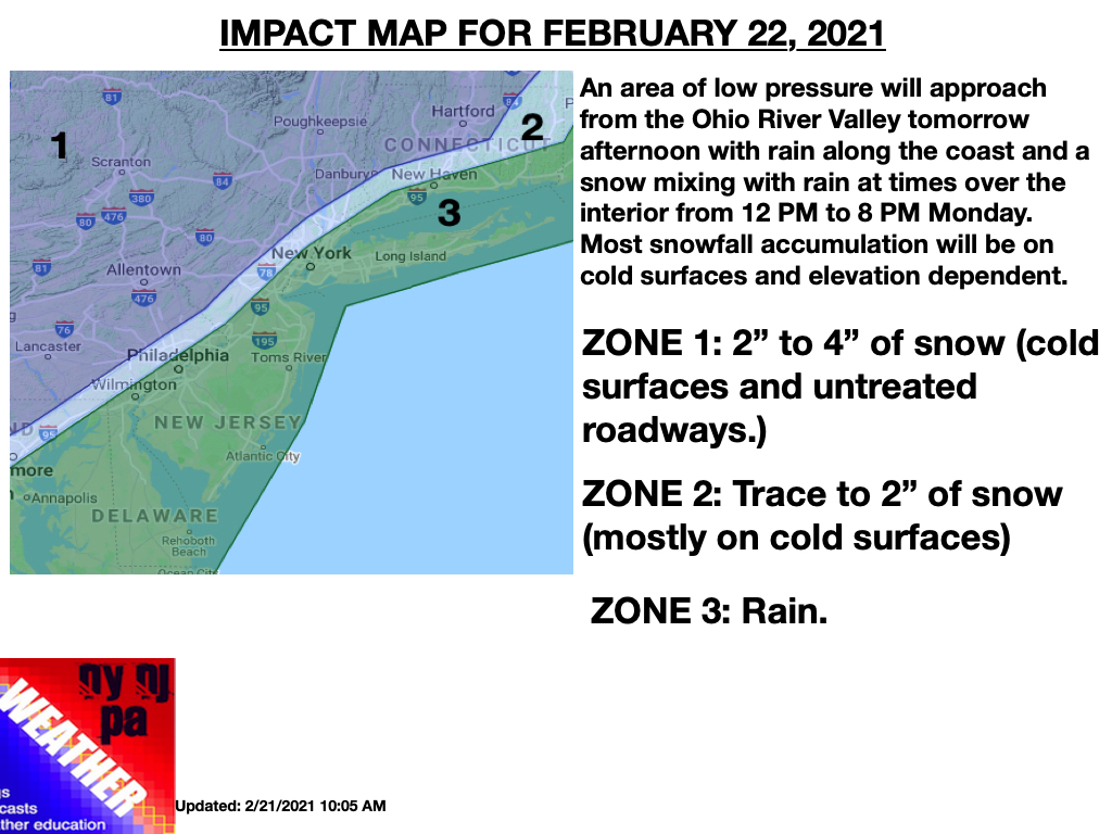
More Snow is on the way manana. Here is the latest from Steven D – great map.
NYC mix to rain
NNJ/LHV – C-2”
NWNJ/HV/EPA -2-4” – PB Land, Titi and Uncle Mike. Sara, Nieces of Green Meadows.
Timing Start -11-12AM ish west to east
Ending 4-5PM ish west to east
EURO

HREF says this

We warm up mid-week and it will feel like Spring! Only 27 days away to equal sunlight and darkness.
Do not be fooled folks cause Mother Nature will have a trick up here sleeve for March – in like a lion and out like a lamb??? Time will tell. Old Farmer’s Almanac calling for a March blizzard 3rd week?? Who knows but winter threats until about mid March are on the table:
Fri/Saturday – blue is snow

Sun Angle
This is the time of year we start to see and feel the Vitamin D we so earnestly need to survive on this planet – truth! It helps with our immune systems and fights off virus’s and bacteria’s! It also prevents and keeps snow from accumulating as much on roadways – Joe O likes the sound of this though we all like the sound of his voice with the call before a snowstorm!! Well at least I do HAHAHA!!

FRANKLIN BABY!
I have recorded 50” so far on this winter season which equals a BOOOOOOOOOM!!
This is cool:
Here is how this season compares to last season https://t.co/8z68ozB9yI pic.twitter.com/XgtCCoTzJN
— Nicholas Isabella (@NycStormChaser) February 20, 2021
Notes from last storm – called originally 4-8” and it stood well then went 6-10” after seeing the convective nature of the storm in the south which WOULD have boded well if not for a dry level of air at the 500mb level (5 miles) above our head in the LHV and NNJ. CNJ got this better – a mere 50 miles South of my call overall BUT I did hit the 6” -6.5” mark so grade wise would be a B Minus. My students would appreciate such as I hope you do my forecasting as I do you. Storm totals well reported!
…NEW JERSEY…
…BERGEN COUNTY…
WESTWOOD 6.5 IN 0840 PM 02/19 TRAINED SPOTTER -ZOOOOO!!
1 WSW WASHINGTON TOWNSHI 5.8 IN 0705 PM 02/19 TRAINED SPOTTER
FAIR LAWN 5.3 IN 0800 PM 02/19 COCORAHS
RIDGEWOOD 4.6 IN 0800 AM 02/19 TRAINED SPOTTER REALLY 8AM it snowed until 8PM give me a break!!
EAST RUTHERFORD 4.5 IN 0720 PM 02/19 TRAINED SPOTTER
MAHWAH 4.1 IN 0145 PM 02/18 PUBLIC – Kyle K an inch you say?? Ahh stick to the chords my man
PARK RIDGE 4.0 IN 0326 PM 02/18 PUBLIC
…ESSEX COUNTY…
WEST ORANGE 5.5 IN 0700 PM 02/19 PUBLIC
LIVINGSTON 4.1 IN 1100 AM 02/19 PUBLIC
CEDAR GROVE 3.8 IN 0415 PM 02/18 PUBLIC
NUTLEY 3.5 IN 0130 PM 02/18 PUBLIC
NORTH CALDWELL 3.1 IN 0420 PM 02/18 TRAINED SPOTTER
…HUDSON COUNTY…
KEARNY 5.0 IN 0915 PM 02/19 COCORAHS
HOBOKEN 4.7 IN 0256 PM 02/19 TRAINED SPOTTER
HARRISON 4.7 IN 0715 PM 02/19 CO-OP OBSERVER
…PASSAIC COUNTY…
1 SSE BLOOMINGDALE 6.1 IN 0700 PM 02/19 TRAINED SPOTTER
WAYNE 5.0 IN 0900 PM 02/19 TRAINED SPOTTER
BLOOMINGDALE 4.8 IN 0100 PM 02/19 TRAINED SPOTTER
…UNION COUNTY…
NEWARK AIRPORT 5.3 IN 1200 AM 02/20 OFFICIAL NWS OBS
1 WNW CRANFORD 4.7 IN 0645 PM 02/19 TRAINED SPOTTER
SUMMIT 3.9 IN 0320 PM 02/19 PUBLIC
MOUNTAINSIDE 3.5 IN 0635 PM 02/19 PUBLIC
…NEW YORK…
…BRONX COUNTY…
1 SSW EAST TREMONT 6.0 IN 0151 PM 02/19 PUBLIC
1 W THROGS NECK BRIDGE 5.1 IN 0800 PM 02/19 TRAINED SPOTTER
PARKCHESTER 3.5 IN 0300 PM 02/18 CO-OP OBSERVER
RIVERDALE 3.3 IN 0217 PM 02/18 TRAINED SPOTTER
…KINGS COUNTY…
2 SSW FLATBUSH 4.6 IN 0800 PM 02/19 BROADCAST MEDIA
1 ENE CONEY ISLAND 4.0 IN 0800 PM 02/19 PUBLIC
3 SE FLATBUSH 3.5 IN 0300 PM 02/18 PUBLIC
2 NE CONEY ISLAND 3.5 IN 0400 PM 02/18 TRAINED SPOTTER
…NEW YORK COUNTY…
CENTRAL PARK 4.4 IN 1200 AM 02/20 OFFICIAL NWS OBS
YIKES just a bit outside no?? Forecast made on Jan 21 even though they KNEW the PV had split and was heading our way – deniers much?? LOL!! Nah just sticking to the script of Al Gore and John Kerry.
Friday Funny: nature makes a mockery of month-ahead model forecasts. https://t.co/srMxomeCmA
— Watts Up With That (@wattsupwiththat) February 19, 2021
Updates to come and do not put that shovel away just yet peeps!!
Al Q
