
UPDATE – EURO DROPS THE MIC!!! DANGEROUS STORM BREWING!!!!
Related Articles
PEEPS,
MONSTER STORM!!!!
18-30″ AREA WIDE
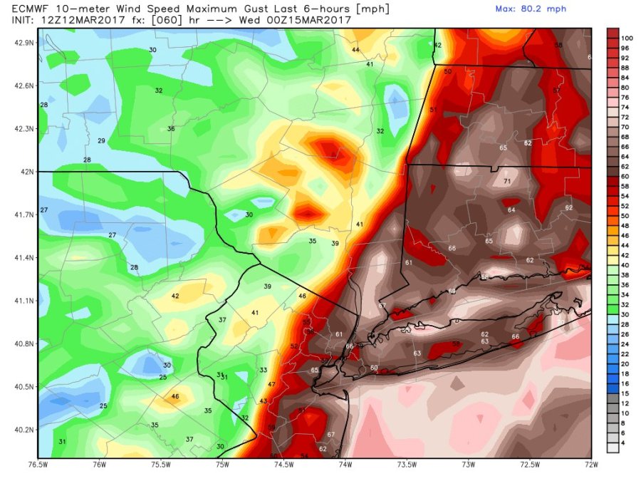
WINDS 20-45 MPH WITH GUSTS UP TO 65 MPH
CRIPPLING /PARALYZING STORM
POWER OUTAGES =LIKELY
NO SCHOOL – UMM I THINK SO FOR TWO MAYBE 3 DAYS IF SHE COMES TO THE POWERFUL FRUITION THE EURO AND 4 OTHER MODELS ARE HINTING AT
This is my super bowl, world series, world cup, Daytona 500, Final Four (hate NBA) – this Storm just got a steriod injection – YES NO POOP!!
The EURO JUST
THE MAPS PLEASE
WINDS: THIS HIGH END TROPICAL FORCE LIKE FLOYD !!!!!!!!!!!
HURRICANE FORCE ON THE COAST!!!
SNOW AMOUNTS WHOOAAA NELLIE!!

RPM MODEL THE PROS TV METS USE GOT MY HANDS ON IT – DON’T TELL ANYONE YOU HEAR!!!!

THIS FROM MY WEATHERBOARD GOD/GURU FRANK THE P – A VERY DANGEROUS STORM – READ IT AND PASS ALONG TO FAMILY AND FRIENDS!! JUST CAME OFF THE WIRE !!
This afternoons weather models showed outputs I have not seen many times in my lifetime. The short range models and foreign models show a powerful storm capable of paralyzing the area. The trend I’m seeing in the upper levels is for the sub tropical jet stream to be stronger, which means a stronger southern energy, and the mid level trough is sharper. The combination of the two develops a dangerous surface low pressure system, likely under 980mb, found off the coast of NJ. Snow rates could be anywhere from 3 to 5 inches an hour at times. Sustained winds of 30-40mph with gusts in excess of 70mph from NYC and points S&E. Snow accumulations ranging from 18 to as much as 36 inches (the 30+ snow amounts are confined to Eastern PA, NW NJ, and SW NY on latest guidance). NYC and points S&E could see some sleet or rain mix at times, but accumulations will remain well over a foot of snow. Power outages are a concern of mine, especially for NJ and NYC Metro.
Now, there’s still a full day of model runs to digest and changes in track could lessen impacts. However, this is a very dynamic set up and I think the EURO, CMC, UKIE, AND short range models are showing these types of conditions for a reason. This evening I will have a synopsis and 1st call snow map on the forum. Please prepare yourselves and inform friends and family of what we could possibly be dealing with on Tuesday.
