
ROUND 2 from MR. NOR, Friday again?? The pattern is………
Related Articles
Peeps,
To much going on with work, wx club weenies Zoom – Abby, Thomas and Geeb, Jack snuffed me in class so coal for Xmas!! Rimeeland and Waller are the Dynamic Girl Power Wx Girl!! Texts, cell phone blowing up last two days and ask ANY of these peeps by and from you peeps and they’ll tell you I nailed this said 5-6″ plus of rain and I have only 5.03″ unofficial, why you ask? Great question and simple answer – 2 leaves got stuck in my rain gauge wx system thus skewing the amount of rain!! And had to mitigate measures from my basement again – the problem solver in me figured it out WOO HOO!!! I hope !!
Round 2
Do not let your guards down this is the true coastal that is retrograding to the coast towards LI and is coming a bit further west thus bringing more rains and…..WINDS!
Rains 1-2″ more
Winds:
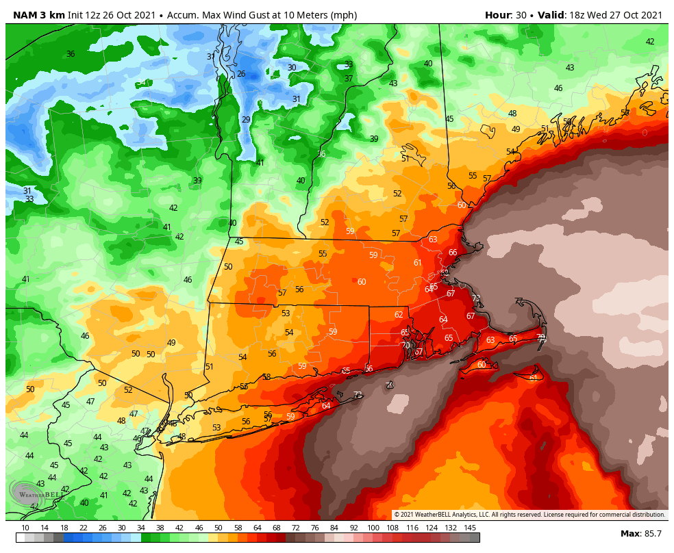
NE NJ – 40-50 mph gusts
NYC 40-50mph gusts
CLI 55-65 mph gusts
ELI 60-70 mph gusts
Coastal NJ – 30-45 mph gusts
Power outages are gonna happen
Cape Cod, Martha Vineyard and the Obama compound will get smoked (not the first time he has or had been smoked LOL!)
Info and Maps
Rain incoming – yellow heavy to moderate stuff until about 3AM

WINDS scale in colors below

Storm surprise
From my analysis, the 0 and 6z model that best resolved the intensity and location of these two low pressure areas is the 3km NAM. GFS was pretty close as well. RGEM/HRDPS and ECMWF showed one consolidated low s. of RI – big fail. pic.twitter.com/rGTV9XXLws
— Yaakov Cantor (@yconsor) October 26, 2021
Friday again
Trying to take these one at a time here, but this I can’t help but notice the pressure gradient here showing up on modeling for Friday PM. Looks like another period of decently gusty winds possibly preceding rainfall w/ the storm during the early part of Halloween Weekend. Just something to keep tabs on. We’ll see if this system unravels a bit as it heads into the Northeast, but an active stretch nonetheless.
Edit: We’ll need to monitor the strength of the LLJ and see if it’s co-located with heavier precip and monitor any potential inversions once mesoscale guidance comes into range. This seems like it could be a bit more impactful from a wind perspective than the afternoon from NWS Mount Holly office has indicated.

The pattern is………LOADED!!
Active period for sure peeps, White gold quite possible for the Ski Mountains in NE and NY possibly. Wish it were December with this!!
All those orange colors indicated blocking and teh blues are storms – colder air and lower pressure – every few days they swing through. Quick flip to winter in early Nov.
Enlarge this image Click to see fullsize

Updates to come.
Be careful, safe and have a great night.
Ciao
AL Q
