
Warm, Wind and Rain tonight through Friday, Squalls and Arctic plunge, CME’s, Green= NOT!
Related Articles
Peeps,
As I have been saying and Upton hearing me – winds are going to crank for hours from about 1-2AM until about 6-8pm as max gusts time with about an inch of rain.
Wind Alerts are up for the entire region, with a High Wind Warning hoisted for Suffolk & Nassau Counties (as well as most of southern coastal CT) with Wind Advisories issued elsewhere.
Upton:
CONFIDENCE IS HIGH IN A STRONG WIND (WIND ADVISORY) EVENT TONIGHT
ACROSS THE ENTIRE AREA, INCLUDING NYC (45-55MPH GUSTS), WITH
MODERATE TO HIGH CONFIDENCE IN HIGH WINDS GUSTS (55-65MPH) FOR
LI AND SE CT UNDER THE CORE OF THE 75-80 KT LLJ. THE TIMING FOR
PEAK STRONG TO HIGH WIND GUSTS CONTINUES TO CENTER AROUND 6-12Z
FRI.
Enlarge this image Click to see fullsize

Enlarge this image Click to see fullsize

HREDF says in the Poker Game – I will se yuor wind map and raise you a finskie or Hamilton and call you on it!!
WOOF – From Superstorm at 33nRain (pro Met) That pink jumped a bit west = 60-75 mile wind gusts – we still are in the 45-60 in NNJ

Shore is 55-70MPH wind gusts
Peeps these are strong Tropical Force winds so be prepared not scared – Paulie juice up the generator and get some back up in teh form of Petro. After this storm exits then he Arctic Air plunges in and temps will drop about 30 degrees in a 2 hour period/ Welcome to what is known as the Grand Solar Minimum!
Winds: 45-55MPH for NNJ, NYC Metro, and CT from about 1-2AM lasting until about 6-8AM maybe a bit longer
Shore gets walloped with 55-75mph wind gusts
Rain about 3/4″ – 1.25″
Temps in the 50’s
3K Hi Resolution Model says
WINDS – getting stronger oofa – fire up the generator!

Precipitation – RAINFALL AMOUNTS

They will see a changeover to a mix up in NWNJ!! Maybe ending as some wet snow, sleet and freezing rain

Rich and Carol, Guerci Land – wowza – ALLEET! SLEET!!!

Squalls and Arctic plunge
The Plunge – look at that wave – incredible to see!

At one one point PB land will be freezing and I’ll be almost 60 degrees a mere 20 miles by crow flight! a 28 degree temperature difference

SQUALL possible for NW NJ LHV and even to CT

For now though, keep an eye on the radar for Saturday. Threat is there for some nasty snow squalls even to the coast.

CME’s
The suns had a a MAJOR CME the other day and now we have 2 that will be facing our planet – watch for uptick in Puffers adn Shakers peeps, thinking another strong or two shakers and maybe some puffers going off to compliment them!

Green= NOT! OFF SHOER WIND TUIRBINES ARE FALSE!
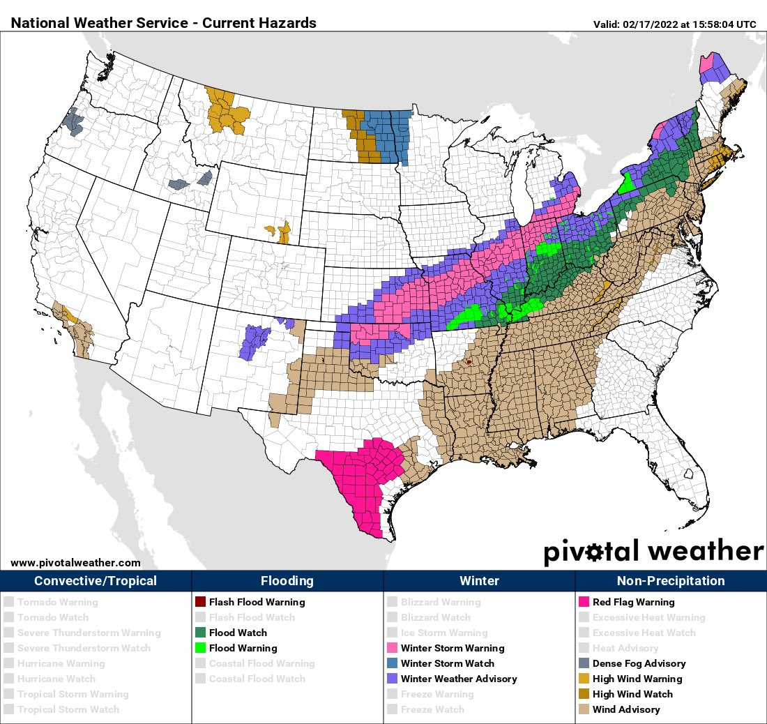
Eye opening and disturbing!
1/3 OF usa UNDER WATCHES, ADVISORIESA ND WARNINGS!!
Be safe, God bless you, keep the faith in him, his son and the holy spirit.
Watching next Thursday Friday for winter to return with a storm – snow, ice possible!
Updates to come.
AL Q
