
Windy Wednesday Night, 2010 Dec.Repeat?, Hunga Tonga News, Died Suddenly, Misc.
Related Articles
Peeps,
Well the Fri/Sat storm potential was just that potential and never materialized even though for 4 straight days the GFS, EURO models had advertised. We had two slight rain events that kept conditions raw and rainy, dark and gloomy, Friday morning and Sunday afternoon, evening were so November like. The progressive nature of the pattern just overwhelmed the pattern.
Wednesday night we have a cold front moving through. Ahead of the front the temps my reach 60 degrees Wednesday and rains and winds may reach 25-35 mph gusts in some heavier downpours. Then when the front moves through we have the backside winds that may reach up to 25-35 mph as well. Windier at the shores and out on Long Island.
2010 December Repeat??
If anyone recalls one of the best Decembers ever in the 2000’s and possibly of my lifetime (53 years!) We;; we could be rivaling this IF the patern come to fruition. Here was my call on Nov 20th:
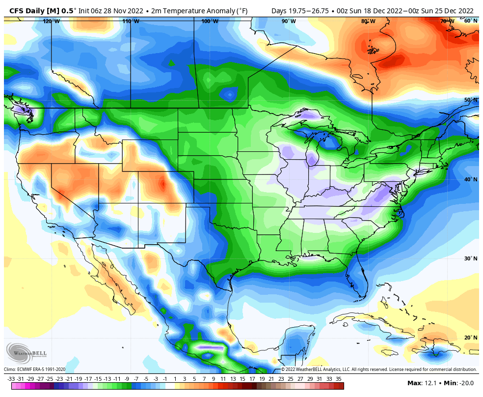
December Temp. Outlook
December temps are already being forecasted to be below normal and we have a very wintry pattern setting up. I think our 1st snows area wide is by the Dec 15th time frame. Can I go 2 for 2? Time will tell.
One hell of a map that is reminsicent of great December of the past witha Negative AO, NAO and EPO ish
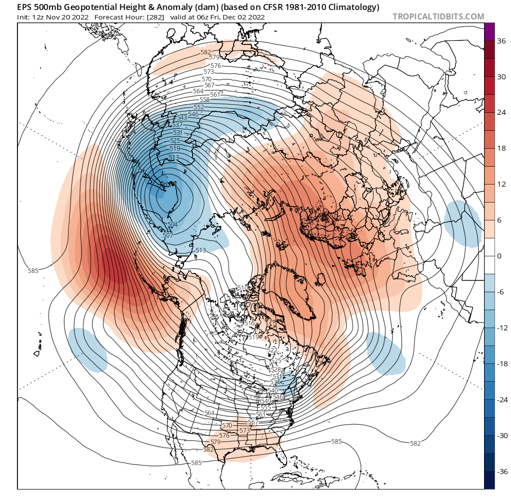
Well it may just happen: This is a beast of map that barks for cold n snow along the east coast. We have the famous and so elusive “Ridge Bridge” that connects the North Atlantic to the Pacific over and through Greenland, Canada and Alaska.

As is this is the Ridge Bridge hat Nick Psomaris from 33nRain posted – credit to all them:

Folks, I am stoked about this upcoming pattern.
If you don’t have your thermals and fiewood ready we’ll better get on it now!!
Snow Queen, Prince, and Princess (just so everyone knows I am the Snow King – self proclaimed in 2013!!) you better get your jig on and ready!!! BOOOYAHHH!! No fricking TV met will ever talk this dirty this far out!!! They’ll wait until 24 hours before and then pound their chests. Warmicists that will have it shoved in their faces.
This whole evolution starts thi sweekend ans we start tranistioning next week. Some solutions would absolutely wreck havoc in mid December (meaning a KU event, classic Northeast Snowstorms soem prolific)but to far out for that at this stage, even for a snow weenie like me!
December Temps = way below normal for this time period of Xmas week!!
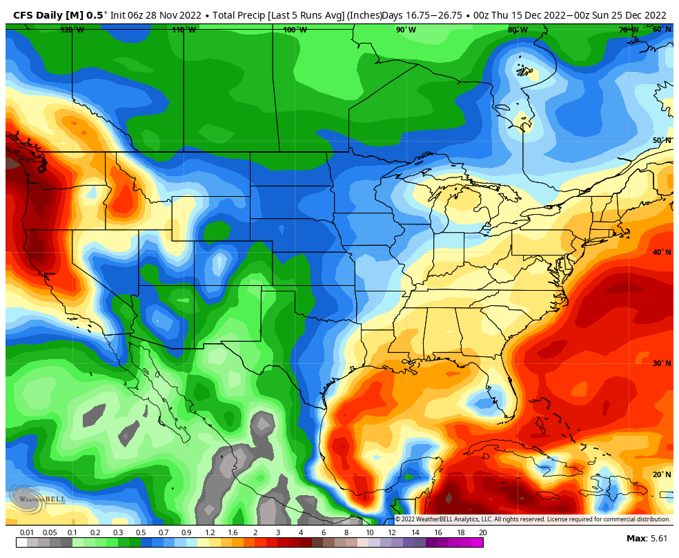
With an abundance of precipitation up to 2″ (10:1 ratio for liquid to snow!!)!!
Hunga Tonga News
Well, this massive volcanic explosion back in January, the 15th to be exact this year is wrecking havoc on both hemispheres. The Southern Hemisphere was whacked this past winter and spring and maybe going into a volcanic summer, a year without a summer is possible. This Volcanoe, which no one really heard about and why? It would cool the earth and cause havoc among the weather patterns. They want to tie it to Climate Change which is a false theory folks, milking, bilking and taking billions from us hard working individuals and spending our tax money on ridicolous programs and ideas. I digress sorry.
So the massive amounts of water vapor:
“The eruption was from under the water. I looked up 146 teragrams that equals the estimated displacement of water. In gallons: 1219429049997
If I read the conversion right from www.unitconverters.net then that is 1.22 trillion gallons”
That is warm salt water that is electrically charged is going to move to the magnetic poles which are NOT due North or South anymore. These magnetic poles are shifting and have been accelerating their move. The Geomagnetic North Pole is in Hudson Bay region now.
The water vapor crossed the 20 dgree lattitude North at the end of August and is of mid month November) above the 45th lattitude North parallel now. It is moving fast and at this rate of acceleration if you project it means it will be above the 60th parallel lattitude North by about mid January. That would mean all of this warm moist air full of latent heat will push the cold dense air in the arctic region south, downward. It will disrupt the polar vortex and knock it around, maybe even split it. A weak Polar Vortext means usually a colder North America, Europe and Asia.
For those curious about the Polar Vortex and it’s role it plays during the winter…
Here’s a good, simplified break down from Harvey Leonard and Judah Cohen on how the PV works. pic.twitter.com/HX2ZyvRPNE
— BGWX (@BradyBGWX) November 27, 2022
Some info:
1.8x the magnitude of Pinatubo!? If that’s the case, it will have an impact on the Winter. Probably nowhere near the impact it would’ve had if this erupted above water, but an impact nonetheless. https://t.co/SznTyCgEHf
— Mark Margavage (@MeteoMark) November 28, 2022
The Stratospheric water vapor injected by the eruption of the Hunga-Tonga Hunga Volcano in Dec 2021 has now made it past 45N. I continue to monitor this as part of ongoing research related to how this anomalously high H2O concentration might impact the #PolarVortex #wxtwitter pic.twitter.com/gQVdDmFmG6
— Mark Margavage (@MeteoMark) November 28, 2022
THIS IS INCREDIBLE!!!
Died Suddenly
Incredible documentary on the number of young jabbed folks (it is NOT a vaccine and fauci even admitted to this in a deposition with the Mizzou Ag on Wednesday!) who have died sudedenly. It is scary and should give any reasonable person a moment to pause. Don’t deny it or call it a conpsiracy theory becasue you dont agree or are in denial for you might be scared but listen and investigate.
This is the first time I have watched ANYTHING lasting over an hour in years. PLEASE watch and share #diedsuddenly EVERYWHERE on EVERY platform. This was VERY well done and Stew showed real courage doing this. Watch b4 you doubt. #COVID #CovidVaccine https://t.co/IrcIRCl5MV
— Tom Renz (@RenzTom) November 22, 2022
Watch this if you choose.
13 year old Jackson Mohr #diedsuddenly from a heart attack. His parents found him unconscious in bed and rushed him to the hospital. He died 3 days later. He won cadet of the year, and had a bright future. RIP soldier 🙏 pic.twitter.com/3EV8rdn7cO
— DiedSuddenly (@DiedSuddenly_) November 26, 2022
Heartbreaking:
16 year old Faith Ranson is in constant suffering since her second dose of Pfizer 💉💉
She has been to numerous specialists with zero answers. pic.twitter.com/DHeaPiFYlY
— DiedSuddenly (@DiedSuddenly_) November 27, 2022
Renowned Fitness Trainer and Coach Eric Phillip Fleishman, 53, DEAD SUDDENLY…
Regularly contributed to the magazine "Muscle and Fitness"…
– hitc, hollywoodlanews
— Dr. James E. Olsson (@DrJamesOlsson) November 28, 2022

Some BDay Present?!!!
PITTSBURGH, Pennsylvania – AMBULANCE DRIVER, 23, DEAD after HEART ATTACK WHILE DRIVING…
Collided with another vehicle…
Ambulance driver and Paramedic Nick Theofilis suffered CARDIAC ARREST WHILE DRIVING the AMBULANCE…
3 total taken to the hospital…
– ems1 pic.twitter.com/wN2TdnEcox
— Dr. James E. Olsson (@DrJamesOlsson) November 28, 2022
1… BREAKING. According to recent mortality data published in Lancet, Science, etc. … There was virtually no excess mortality in India until they vaccinated, stating with the frail and elderly. Then mortality by month exploded by >300%, massive.
Sources: next tweet /2… pic.twitter.com/9B91eQ1SVd— Denis Rancourt (@denisrancourt) November 27, 2022
As an Oncologist I Am Seeing People With Stable Cancer Rapidly Progress After Being Forced to Have a Booster – The link with clots, myocarditis, heart attacks and strokes is now well accepted, as is the link with myelitis and neuropathy. Stop the shotshttps://t.co/3FiXYi9iHU
— Adnan Al-Daini Ph.D. (@respect65) November 26, 2022
Misc.
SCAM
The EV hoax… pic.twitter.com/9MG9phLrn8
— .. (@Xx17965797N) November 26, 2022
This could be the USA in a couple of years or sooner. They are moving to this and want this in place
Guangzhou city today. If Chinese government remotely switches your health passport to code yellow, you will become homeless.
Because with yellow code on your phone, you can't go back to your apartment, stay at hotel, take any public transport…trouble to get food too ⚠️
— Wall Street Silver (@WallStreetSilv) November 28, 2022
Electric green scooters that have reached end of battery life.
Due to the batteries being so expensive to replace, electric scooters are abandoned because disposing of them any other way is dangerous and expensive. pic.twitter.com/9O4qD4QzYE
— .. (@Xx17965797N) November 28, 2022
Archbishop Carlo Maria Vigano, former Secretary-General of the Vatican, warns that:
The WEF through the C19 crisis has either direct control or blackmailed world leaders into following the plan of mass devastation through vaccination & submission to a new world order. pic.twitter.com/ZzTolJ8ql4— New World Odor™ (@hugh_mankind) November 27, 2022
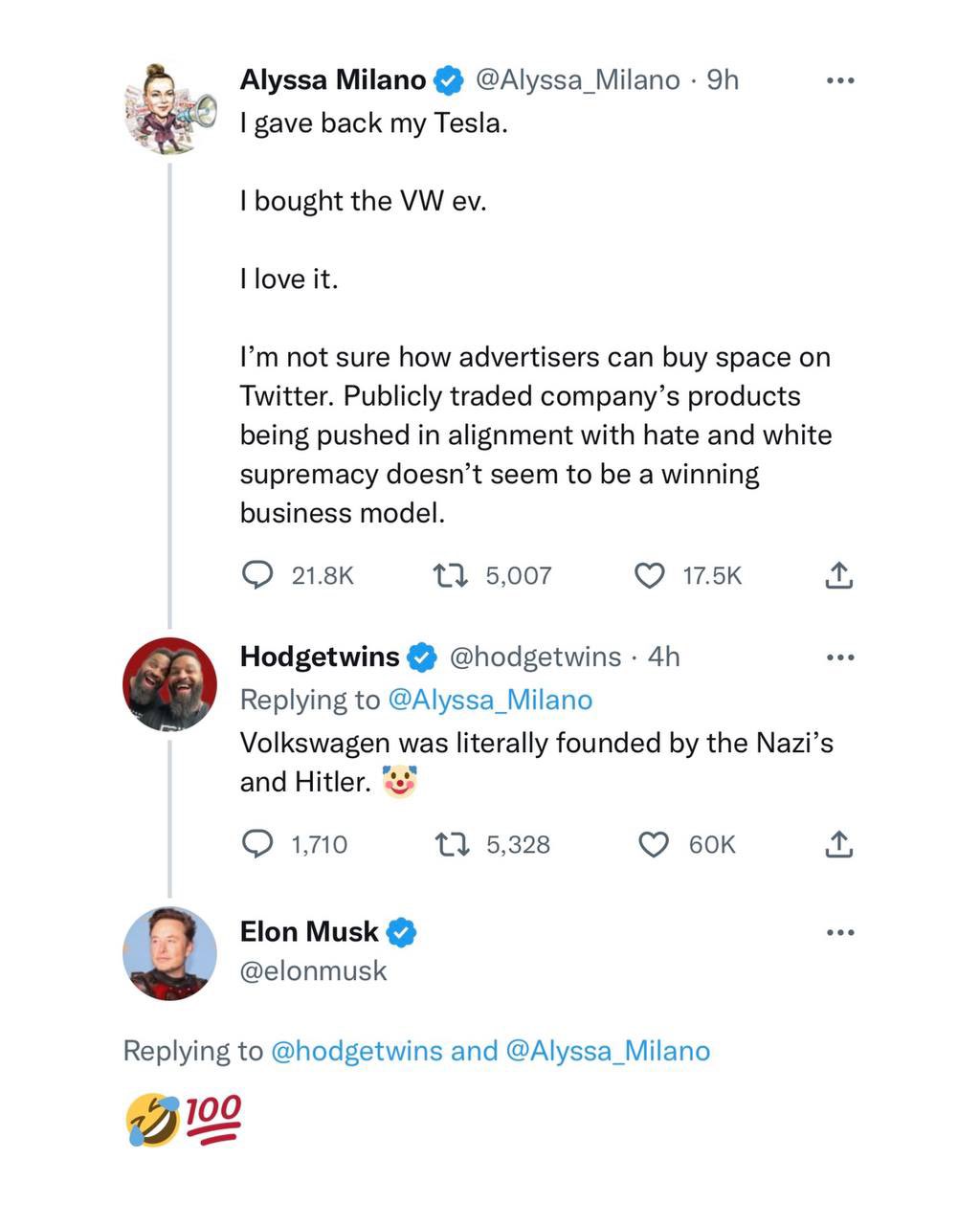
IDIOT virtue signaling hollywierdo!
🤬Netherlands to close up to 3,000 farms to comply with EU ruleshttps://t.co/OgEdI0G908
— .. (@Xx17965797N) November 28, 2022
Updates to come.
Keep the faith in God and be well.
AL Q
